Tuesday, July 16, 2013

Upcoming Events July & August 2013

The following events are scheduled for the Isabella Conservation District (ICD) over the next six weeks.

Isabella County Youth and Farm Fair (21-27 July 2013)
     -ICD will be sharing a booth with the USDA Natural Resources Conservation Service at the Isabella      
      County Fair Fairgrounds.  Our booth can be found in the Merchants' Building at the fair.  I will be on      
      hand several times during the week with specimens to examine and posters and other items to hand out.

Backyard Birds program at the CMU Museum of Cultural and Natural History (30 July 2013 at 10:00AM)
     - I will be presenting a program on Michigan Birds at the CMU Museum using real and replica artifacts
       and specimens.  This is a great opportunity to interact with preserved specimens from the museum
       collection.  This event is free and open to the public.  The CMU Museum is located inside Rowe Hall 
       on the Campus of Central Michigan University.

Clean Sweep & Household Hazardous Waste Collection (10 August 2013)
    -  ICD will be hosting our second Clean Sweep & Household Hazardous Waste collection of the year at
       the Isabella County Fairgrounds beginning at 9:00AM for a listing of the types of items that are 
       accepted please look here


Connecting with the “Wild Life”… Don’t let today’s technologies keep you inside…Create your own adventure! Unplug and Reconnect with Nature!! at Deerfield Nature Park (24 August 2013 from 11:00AM to 4:00PM)
      - I will be participating in this event with some sort of hands on nature activity (TBD).  Other activities 
         include:


·                        GEO Caching 
             Disc Golf Demonstrations and/or Mini Workshop
·                        River testing 
·                        Bridge Tour/Nature Hike 
·                        Nature Journals 
·                        Petting Zoo
·                        Sharpie Tie Dye

            This event is being set up by the Isabella County Parks and Recreation Department.  Please call 
            (989) 772-0911 ext. 340 for more information

Monday, July 15, 2013

A Mountain and a Lighthouse - Photos from Maine.

This blog has been silent for the last two weeks.  I was on vacation in New York, Vermont, New Hampshire, Massachusetts, and Maine - camping much of the time, with no internet access (or interest in blogging on vacation).  I am only going to bore you with eight photos of scientific/cultural interest and then resume regular posts on topics that relate to Mid-Michigan.

The first six photographs are from Cadillac Mountain.  Cadillac Mountain is the highest in Acadia National Park - Acadia National Park is located near the Town of Bar Harbor on Maine's central coast and was the first National Park established east of the Rocky Mountains.  Interestingly, Mount Cadillac is the highest point within 25 miles of the East Coast of the United States.  It rises to a height of 1530 above sea level according to the benchmark on the summit.  The mountain (an much of the bedrock of Acadia National Park) is composed of two primary types of rock - Mount Cadillac Granite and Ellsworth Schist.  Like Mid-Michigan, Mount Cadillac was covered by glaciers during successive Ice Ages.  Unlike, Mid-Michigan, Mount Cadillac did not receive deep deposits of glacial till but rather was scraped clean.  (Another Ice Age note: Acadia National park is also home to the only glacial fiord on the East Coast - Somes Sound.) There is a road to the summit of Mount Cadillac and also several hiking trails.  So what does it look like from the top?

On a clear day this is your view...

View from Cadillac Mountain - looking roughly South
 
This view is roughly to the North-Northeast.  Parts of the summit have been roped off in an attempt to restore the sensitive alpine vegetation.  The body of water is called Frenchman Bay
The photos above were taken from an open area that is adjacent to the parking area at the top of Mount Cadillac.  There were probably over 200 people at the summit when we were there - It took a lot of patience to get photos that were not full of people.  This area sees very heavy foot traffic from visitors and offers the best views, but it is not the actual summit of Mount Cadillac.  The actual summit sits a little further south and is hidden by trees, it can be accessed by a gravel trail from the parking lot.  Very few people go to the actual summit - my guess is less than 1% of visitors to the top of Cadillac find the actual summit.  In two trips to the top of Cadillac, we saw four other people looking for the benchmark at the summit - out of hundreds of people at the summit.

Here is the actual summit.

That bump of rock in the center of the photo is the actual summit of Cadillac Mountain.

The USGS benchmark at the summit.

We drove to the summit of Mount Cadillac on two separate occasions during our trip.  Our first trip was clear and sunny.  The day of our second trip was foggy with a heavy mist throughout the day.  Under those conditions this is what you can see from the summit.

View from Mount Cadillac on a less than clear day
There are also several parking areas along the road to the summit - these are best accessed of the way down and also offer stunning views.

View looking to the Northwest - the body of water in the middle left of the photo is called Eagle Lake.  The water to the right of the photo is an arm of Frenchman Bay.

As the highest point around, Cadillac Mount is visible from many points along the coast of Maine.  I took this photograph from Lamoine State Park across Frenchman Bay.  If you look closely you can see the lights of cars as they come down Cadillac Mountain.


So where is Cadillac Mountain in relation to Mid-Michigan?  It is roughly on the same latitude as Houghton Lake, but to drive there by the fastest route will take approximately 17 hours and cover more than 1,130 miles of driving across Michigan, Ontario, New York, Massachusetts, New Hampshire and Maine.

The other two photos that I want to share are of West Quoddy Head Lighthouse near Lubec, Maine.  Located a further two hours "Down East" from Acadia National Park.  West Quoddy He8ad is the easternmost point of the United States.

A lighthouse at West Quoddy Head was first authorized by Congress in 1809.  The current lighthouse was constructed in 1858.  With its distinctive paintjob of red and white stripes it is one of the most recognized lighthouses on the East Coast.


So where is West Quoddy Head Light in relation to Mid-Michigan?  It is little further north, roughly on the same latitude as Sleeping Bear Dunes National Lakeshore.  If you wanted to drive from Sleeping Bear Dunes to West Quoddy Head it would take you over 20 hours and cover nearly 1300 miles by the fastest route.

Monday, July 1, 2013

A Historical Anniversary and A Brief Hiatus

Today marks the 150th anniversary of the Battle of Gettysburg (July 1st-3rd, 1863).  It was the largest battle fought on American soil and marked the high point of the Civil War for the Confederacy.  We visited the battlefield in 2009.  This was my favorite photo from that trip.

Bluebirds and Bayonets © Michael LeValley
Eastern Bluebird (Sialia sialis) on the First Minnesota Infantry Monument

Blog posts over the next two weeks will be sporadic as I will be out of the office during that time.  Regular Monday through Friday blog posts will resume on July 15th.

Friday, June 28, 2013

Aquatic Invertebrates at Hall's Lake - A "4th Thursday" program with the Chippewa Watershed Conservancy

Yesterday I went out to the Hall's Lake Natural Area in western Isabella County to take part in the Chippewa Watershed Conservancy's 4th Thursday at Hall's Lake nature walk program.  I would be co-leading a program on aquatic macro-invertebrates with Doug Valek, retired Biology professor from Central Michigan University.  The property that we would be exploring is not currently owned by the Chippewa Watershed Conservancy, but is currently being held in trust by Larry and Judy Schaftenaar with the expectation that the CWC will eventually purchase the land to preserve it.  Larry and Judy currently allow public access to their parcel (which connects to the CWC's Kabana and Neely Preserves) except during deer hunting season.


This was my first time visiting Hall's Lake and I did not know what to expect so I arrived early to explore the property a little bit.  The property is almost entirely wooded and includes a mixture of Southern and Northern species.  After a few minutes exploring the area on my own, I heard Larry calling to me from the parking area.  He took me out to show me the wooded pond that we would be investigating - it is a kettle pond over a ridge from the main trail that I would never have known was there without Larry telling me.  He also told me about a wooden bridge across a slow moving stream further along the main trail.  I went along the trail to the bridge and Larry went back to the parking area to greet people as they arrived.  Eventually a total of 18 people were gathered in front of Larry and Judy's house (four more people would join us later in the morning for a total of 22).  After a short introduction by Doug Valek and myself, the group walked back into the woods and began sampling the pond water.  We eventually would sample in three locations (pond, stream, and lakeshore).  Below are some pictures from the day.

Retired CMU Biology professor Doug Valek (right) helps participants identify aquatic invertebrates

Gathered around a table for up-close views
A Water Strider on the side of a washbasin

The pond is the open area in the background - the center of the pond is filled with low shrubs.

The pond was full of Green Frogs (Rana clamitans)

Much of the forest floor around the pond was carpeted with Ground Pines (Lycopodium sp. - possibly L. dendroideum)

My favorite picture of the day - Ground Pine and Green Frog

Doug Valek helps some of the younger participants with identification.

Some of our finds  - (clockwise from lower left) predaceous diving beetle larva, damselfly nymph, dragonfly nymph, damselfly nymph, and predaceous diving beetle larva.

A listing of the different aquatic macro-invertebrates that we found.

For a copy of the identification guide that we used, visit the University of Wisconsin Extension Office website

So what was the highlight of the day for me?  For me it was finding Clam Shrimp.  I had never seen them before - unfortunately due to their fast movement and the low light, none of my pictures of them turned out.  Looks like I have a reason to go back.


Thursday, June 27, 2013

On Tattered Wings

This bee must be nearing the end of its life.  Check out the tattered condition of the wings (especially the left side).  Found on a Common Milkweed (Asclepias syriaca) in the field behind our office 25 June 2013.


Wednesday, June 26, 2013

We don't belong - Non-native plants in Mid-Michigan.

Sometimes it is easy to forget how many of the plants that we see every day do not belong in their habitat.  Below are a sampling of some of the non-native plant species that can be found naturalized in Mid-Michigan (and across much of North America).  How many of them can you identify?

Bittersweet Nightshade

Bull Thistle

Chicory

Cow Vetch

Harebell

Dame's Rocket

Spotted Knapweed

Teasel

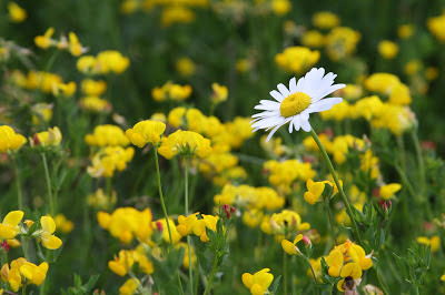
Bird's Foot Trefoil (yellow) and Ox-eye Daisy (right)

Corn Cockle

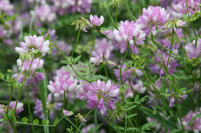
Crown Vetch

Deptford Pink

Everlasting Pea

Motherwort

Musk Mallow

Stork's Bill

Bladder Campion

Bouncing Bet

Hoary Alyssum

Queen Anne's Lace (Wild Carrot)

White Campion

White Sweet Clover

Black Mustard

Butter-and-eggs

Common Mullein

Common St. John's Wort

Fistulous Goat's Beard

Showy Goat's Beard

Moth Mullein

Rough-fruited Cinquefoil