Showing posts with label dunes. Show all posts

Monday, September 26, 2016

Field Trip - Pyramid Point Hiking Trail

Shara and I spent the weekend camping near Traverse City.  On Saturday (24 SEP), we went to Sleeping Bear Dunes National Lakeshore and hiked a section of the Pyramid Point Trail.  This popular trail segment leads to a bluff that rises 300 feet above Lake Michigan.  The trail to this overlook measures about 0.6 miles one way (for a 1.2 mile round trip).  The total elevation change of this trail is more than 200 feet, with about 140 feet of that coming in the final 0.2 miles of the climb.  If you are not used to climbing hills it can be a challenge, but the view is entirely worth the effort.

The trail leads upward

The trail passes though a mixed hardwood forest - including stands of birch

Shara stops to photograph something along the trail

Pay attention to the sign!

Tired, but proud, the view is totally worth it

Me with North Manitou Island in the background

The South Manitou Island lighthouse can be seen on the horizon at the left

The lake is 300 feet down from the top of the bluff!

Looking east along the bluff

A wider angle view of the horizon to the northwest

North Manitou Island - you see the dunes on the island's southwest side


Another view of the eastern horizon

Heading back down the trail

The Pyramid Point Trail is just one of thirteen named trails within Sleeping Bear Dunes National Lakeshore - not counting the trails on the Manitou Islands.  Sleeping Bear Dunes is located about 2 hours 15 minutes from Mid-Michigan.  There is a fee for using the park. Currently, a 7-day vehicle pass costs $15 or an annual pass can be purchased for $30.  There is also a pass for people entering the park on foot or by bicycle ($7 for 7 days).  Check the calendar, there are several fee-free days throughout the year - the next one is scheduled for Veterans Day (November 11th).

Thursday, December 10, 2015

A line in the sand - Mission Creek (07 DEC 2015)

One final post about my recent trip to Mission Creek Woodland Park.

Mission Creek Park is divided into two distinct areas an upland area with sand soils and a lowland area with muck soils.  The lowland is part of the Chippewa River and Mission Creek floodplains.  The transition between the upland area and the floodplain is a steep bluff that is as much as 20 feet high.

While walking along Mission Creek, I noticed an area of the bluff that had collapsed exposing layers of soil on its face.


Fortunately, I had worn my rubber boots so I was able to wade across the river and examine the sand more closely.

The sloping layers of sand (middle of the picture) are an indication that the sand was being moved by wind or water when it was deposited.

One thing that I noticed right away was the presence of cross-bedding in the sand - it was not laid down in uniform horizontal layers.  Cross-bedding is evidence that when this sand was deposited it was being moved by either wind or water currents.  Cross-bedding is commonly found in dunes, ripples, and sand/gravel bars.  The direction of the bedding can be used to indicate the direction of the current.

The cross-bedding was interesting, but I found something else to be even more interesting.


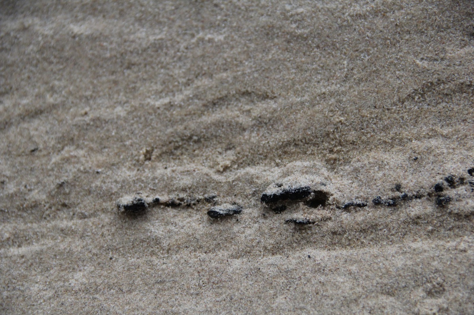
That line of black specks in the center-left of this photo is a layer of charcoal.  A closer view can be seen below.


I dug back several inches into the bluff to see if this was indeed a layer or whether it was a single narrow line.  A single narrow line of charcoal could be caused by the roots of a tree burning deep below the surface.  This was not a line like that - the layer extended back into the bluff.  I did not attempt to dig very far back.  I really did not want to disturb the overlying layers of soil and cause further collapse. 

What could cause this layer? 

One possible explanation is that before the layers above were deposited, the area was lightly forested.  If the forest burned (creating the charcoal), surrounding soils could become destabilized by the lack of vegetation.  Winds then caused the soil to drift, burying the thin layer of charcoal under many feet of sand.  The cross-bedding in the overlying sand makes this theory seem likely to me.

Does anyone else have a better theory?

Thursday, January 30, 2014

Snow Dunes

Many of the schools in the area are closed again today due to blowing and drifting snow.  As I was driving to work earlier this week I noticed how the snow was acting like sand and forming the same types of dunes that would be found in sand.  Under the right conditions, snow can act very much like sand - cold (well below freezing) temperatures that do not allow the snow to melt , fine "dry" snow crystals that do not easily stick together, and of course wind.

I went out into the open field behind the Conservation District office and photographed these small snow "dunes".  None of these features was more than a few inches in height, but they display the classic features of certain types of dunes.

The first feature is a barchan dune.  Barchan dunes form in open areas where there are no obstructions.  A barchan dune is shaped like an arch with the curve of the arch pointing into the wind and arms extending downwind.  In this first picture, there are two barchan dunes on the right half of the image.
 
Snow "dune" features - Barchan dunes to the right of the image
Here is the same image with the wind direction indicated with an arrow and the dunes highlighted with curved lines.  The dunes slowly move downwind an particles are picked up from the face of the dune and deposited on the arms or in the lee space created behind the peak of the dune.

Snow "dune" features - note wind direction (arrow) and barchan dunes (arcs)
Over time, the arms of barchan dunes will intersect with those of adjacent dunes.  The resulting undulating line of dunes in now known as a barchanoid dune

Snow "dune" features - barchanoid dune in center of image
Here is the same image with wind direction and dune indicated.  The barchan dunes from image 1 and 2 are to the right of this picture.

Snow "dune" features - note wind direction (arrow) and barchanoid dune (curving line)
Eventually, barchoid dunes will begin to lose their undulating curves and become straight or nearly straight lines.  This type of dune is known as a transverse dune.  Often many transverse dunes will be found together in rows of ridges and valleys.

This image shows the transition between barchanoid and transverse dune forms.  The closest formation still shows the undulating character of a barchanoid dune, but the dunes doing off into the distance have straightened out forming a series of ridges perpendicular to the wind.

Snow "dune" features - transverse and barchanoid dunes
Another copy of the same image with wind direction and dunes indicated.  the nearest line is a barchoid dune and the further lines have evolved into straighter transverse dunes.

Snow "dune" features - note the wind direction (arrow), barchanoid dune (closest line), and transverse dunes (furthest three lines)
For more information on these and other dune types visit the Great Sand Dunes National Park website.

Wednesday, December 18, 2013

Native Species Profile - White Camas

One of my favorite habitats is the Great Lakes coastal dune complex.  Dunes are often considered among the most threatened habitat types here in the Great Lakes - they can only exist in certain places along the lakes and are often under threat of development.  Because the dunes are threatened, many of the plants that live there are also threatened.  Some of these plants are endemic to the Great Lakes dunes (meaning that they are found nowhere else in the world) like Pitcher's Thistle.  If their habitat is not preserved, they will go extinct. 

Fortunately, other plants that are found in the dune complex can also be found elsewhere so their future is probably more secure. 

One such plant is the White Camas (Zigadenus glaucus).

White Camas (Zigadenus elegans)


Friday, October 25, 2013

Geology Photographs - Great Lakes Dunes

One more post for the week focusing on geology.  Here are some photographs of Great Lakes dune habitats from around the state of Michigan.  The dunes are created by the actions of water and wind.  Waves and currents in the Great Lakes bring sand from the bottom of the lakes and deposit it on beaches.  Wind then blows the sand inland, depositing it in dunes. In Michigan, major dunes can be found along shore of Lake Michigan from the the Indian Border to the Straits of Mackinaw and along the south shore of the Upper Peninsula.  Lesser dune complexes can be found in areas along the Lake Huron and Lake St. Clair shorelines.

Sometimes dunes are created atop bluffs.  These dunes are known as perched dunes.  In the Great Lakes, perched dunes can be found along the south shore of Lake Superior near Grand Marais, MI and along the Lake Michigan shoreline on the northwest side of Michigan's Lower Peninsula

Tower Hill - Warren Dunes State Park near Sawyer, MI

Grand Sable Dunes - these perched dunes are located on the shore of Lake Superior near Grand Marais, MI

Grand Sable Dunes - perched on the Grand Sable Banks near Grand Marais, MI

Grand Sable Dunes
 
From left to right: beach, foredune, interdunal swale, back dune - P.H. Hoeft State Park near Rogers City, MI
 
Vegetation stabilizes the backdune, interdunal swales, and foredune at P.H. Hoeft State Park

Forested backdune - P.H. Hoeft State Park


Perched dunes - Sleeping Bear Dunes National Lakeshore, Empire, MI

Perched dunes at Sleeping Bear National Lakeshore - perched dunes on South Manitou Island are visible in the background

Bedding in the dunes at Sleeping Bear Dunes National Lakeshore near Empire, MI

Interdunal wetland and foredune on North Manitou Island with perched dunes on South Manitou Island in the background - Sleeping Bear Dunes National Lakeshore near Leland, MI

Small foredune and perched backdune on North Manitou Island - Sleeping Bear Dunes National Lakeshore


Wednesday, October 2, 2013

Native Species Profile - Pitcher's Thistle

Coastal Dune - Lake Huron


Coastal dunes are among the most threatened habitats in the Great Lakes. They can exist only in certain places along the shorelines of the lakes and many are under constant threat of development. Despite their close proximity to water, the dunes themselves are arid habitats.  For plants to survive in this habitat they have to be tough.  Some of the plants found here are endemic to this habitat - this mean they are found nowhere else on earth.  One of the endemic plants of the western Great Lakes is the Pitcher's Thistle (Cirsium pitcheri).

Coastal Dune community with Pitcher's Thistle front and center

Pitcher's Thistle, also known as Sand Dune Thistle, can only be found on the shorelines of Lakes Huron, Michigan, and Superior.  The species is listed as Threatened by the US government and Endangered by the government of Canada.  While Pitcher's Thistle can be found in Wisconsin, Indiana, and Ontario (The species is extinct in Illinois), the bulk of Pitcher's Thistle populations can be found in Michigan.  Populations exist all along Michigan's Lake Michigan shoreline north to the Straits of Mackinaw, south along the Lake Huron shoreline to Saginaw Bay, and in the Upper Peninsula along the north shore of Lake Michigan.  A small population is also found in the Grand Sable Dunes along Lake Superior.

Pitcher's Thistle growing on the Lake Huron Shoreline at P. H. Hoeft State Park near Rogers City, MI

Pitcher's Thistle is a has silver-gray foliage and may grow to reach heights of over 3 feet, but is often much shorter.  The leaves are deeply lobed and almost skeletal in appearance.  For a thistle, the plant has very few spines. 

Pitcher's Thistle - note the white flowers and silver-grey foliage

Pitcher's Thistle is a short-lived perennial,  growing steadily for two to eight years until it stores enough energy in its deep taproot to flower.  After producing one or more white blooms the plant dies.  The plant flowers between May and September.  Like other thistle species, the seeds of Pitcher's Thistle are distributed by the wind. 

Pitcher's Thistle is an early successional species.  It is able to become established on bare sand, but is crowded out by other plants.   It does best on shorelines and dunes that are frequently disturbed by natural processes of wind and water erosion.

Pitcher's Thistle blooms


Basic Information


Pitcher’s Thistle 
Cirsium pitcheri

Height:  up to 3’ tall

Habitat:  dunes, shorelines of Lakes Michigan, Superior, and Huron

Flower Color:  white

Bloom Time:  May – September