To this point I've shared two months worth of spring photographs. As of today (June 21st) spring has reached its end, but I have a months worth of photographs still to share. Here are the photos from day 61 through day 70. To see the previous set of images follow this link.
Day 61 (19 May 2019) - Plum flowers
We have a plum tree right outside our back door. It rarely produces much fruit, but every spring it is absolutely covered with blossoms. I photographed these flowers after a light rain covered everything with water and softened the light.
Day 62 (20 May 2019) - Audubon Woods Creek
Another rainy day. This image was taken in a light drizzle at the Chippewa Watershed Conservancy's Audubon Woods Preserve. The CWC owns 23 separate properties, but Audubon Woods is my favorite because of the mature trees. The center of the preserve can often feel ten degrees cooler than the edge. The water trickling over these rocks helps add moisture to the air cooling it even further. Even the color of the woods feels cool as the mist in the air diffuses the light making everything glow green as the sunlight penetrates the forest canopy.
Day 63 (21 May 2019) - Dandelions
Spring wouldn't be spring without dandelions. Homeowners may not love them, but the bees and other pollinators do. Some people are taking notice - the Ziibiwing Center of Anishinabe Culture has adopted the policy of not mowing until the dandelions have gone to seed. I photographed this dandelion bloom in the lawn at the Isabella Conservation District office.
Day 64 (22 May 2019) - Forest Ecology Studies
Most of the programs that I do are in the classroom out of necessity, but every year I take students from Winn Elementary out to Audubon Woods to explore forestry and forest ecology. In this photograph the students are measuring the distance from a stake (representing the center a 0.1 acre plot) to a tree in their study plot. If the tree is within 37 feet of the stake (the radius of a 0.1 acre plot), they will then get an azimuth to the tree, measure the diameter of the tree, and record all of this date on a map of their plot. I keep copies of all this date in the hope that it can be used to record changes in the forest over time.
Day 65 (23 May 2019) - Look up...
May 23rd was another day of forest ecology studies at Audubon Woods. I think actually took more photographs of students on this day than I did on the 22nd, but my favorite photo of the day was taken when the students had gone back to school for lunch. Looking up, I spotted this combination of blue sky, white clouds, dark branches, and yellow-green leaves. With the sun lighting up the edge of a cloud formation I couldn't resist this photograph.
Day 66 (24 May 2019) - Honey Locust Thorn
This photograph was taken right outside my back door. We have a large honey locust (Gleditsia triacanthos) growing only a few feet from the house. This tree provides lots of shade in the summer and a home for many species of birds and insects (not to mention squirrels). The most interesting thing about the tree is the large thorns that grow from a few branches. The honey locust originally developed these thorns as defense against ice age mammals - now they are just a reminder of a time when elephants walked the tundra and forests of North America.
Day 67 (25 May 2019) - Fern Frond
Another photograph from home. This fern covered with a layer of fine spider webs was photographed in the garden on the side of the house. This image has been cropped to a square from its original format.
Day 68 (26 May 2019) - Home, Sweet Home
On May 26th we drove about forty-five minutes from home to visit my parents near Laingsburg, MI. At one point I took a few minutes to walk around their property looking for something to photograph. As I walked past this nesting box in a wooded area, a wren popped its head out of the box. It's not grand architecture, but it's good enough for a wren. If you look close you can see the wren's toes gripping the entrance hole. The bird looked at me for a few seconds and then flew off into the underbrush.
Day 69 (27 May 2019) - Iris
When we moved into our house eight years ago there was already a patch of irises planted on the south side of the house. I think these are Siberian iris, but am not certain. I love the nectar guides on each large landing pad of a petal directing pollinators toward the nectar (and pollen). The large serrated leaves in the background belong to cut-leaved coneflower (Rudbeckia laciniata).
Day 70 (28 May 2019) - Wild Columbine
My final image from this set of photos was taken at the Chippewa Watershed Conservancy's Williams-Blackburn Preserve. Wild Columbine (Aquilegia Canadensis) is one of my favorite late-spring wildflowers. It's very photogenic when the flowers are fully mature (like this one), but I often miss out on finding them so it's always exciting to find a perfect bloom. One really interesting thing to me about these flowers is how hairy they are. Look close and you can see that the petals, stem, and leaves are all covered with minute hairs. I like being able to peer in and see that level of detail.
Showing posts with label Chippewa Watershed Conservancy. Show all posts
Friday, June 21, 2019
Vernal: A Spring Photo Project (Day 61 through Day 70)
Labels:
birds,
Chippewa Watershed Conservancy,
clouds,
ecology,
ferns,
flowers,
forestry,
gardens,
native plants,
nest box,
non-native plants,
preserves,
science,
sky,
students,
thorns,
trees,
wildflowers
Monday, March 11, 2019
Crescent Moon (11 March 2019) and an upcoming event
Tonight's waxing crescent moon as seen from my driveway...
Our next full moon will be on the Spring Equinox (20 March) - I am leading a hike that night at the Chippewa Watershed Conservancy's Sylvan Solace Preserve. For more information, check their website.
Wednesday, February 20, 2019
Full Moon - February 2019
On Monday (18 February 2019) I led a nighttime hike at the Chippewa Watershed Conservancy's Sylvan Solace Preserve. The snowy woods was well-lit by a nearly full moon - at 98% visible the moon could be considered full. This was my third full moon hike of the winter. Altogether, about 50 people have joined me on the three hikes. Monday's hike was attended by nine people.
Monday's full moon was the best we have seen this winter here in Mid-Michigan. Not only was the sky clear (unlike December) and the temperature moderate (not like the 20 below windchill in January, but February's full moon could be considered a "supermoon". A supermoon occurs because the moon's orbit around the earth is not a perfect circle. Instead the orbit is more like an ellipse, resulting in times when the moon is closer to the earth than other times. If the moon is near its closest point at the full moon stage, the moon is commonly referred to as a supermoon.
Although I didn't photograph the hike, I took several photos of the moon from the parking lot before the hike began. This was my favorite image - it has been cropped down to a square shape.
I have one more night hike scheduled this winter at Sylvan Solace. This final hike will take place on the next full moon. This full moon just happens to coincide with the Vernal Equinox on March 20th.
Monday's full moon was the best we have seen this winter here in Mid-Michigan. Not only was the sky clear (unlike December) and the temperature moderate (not like the 20 below windchill in January, but February's full moon could be considered a "supermoon". A supermoon occurs because the moon's orbit around the earth is not a perfect circle. Instead the orbit is more like an ellipse, resulting in times when the moon is closer to the earth than other times. If the moon is near its closest point at the full moon stage, the moon is commonly referred to as a supermoon.
Although I didn't photograph the hike, I took several photos of the moon from the parking lot before the hike began. This was my favorite image - it has been cropped down to a square shape.
I have one more night hike scheduled this winter at Sylvan Solace. This final hike will take place on the next full moon. This full moon just happens to coincide with the Vernal Equinox on March 20th.
Tuesday, February 12, 2019
Tracks, scat, slides, and porcupine butts
It seems like the weather has kept me cooped up indoors all winter. Over the past two weeks, local schools have been in session for a grand total of two days out of ten; on one of the days that they actually had school there was a weather delay. I have already had to cancel or reschedule thirty-five school programs since the second week of January. So imagine my excitement to have nice weather on Saturday (09 February) for a planned animal signs hike at the Chippewa Watershed Conservancy's Hall's Lake Natural Area. Sunny weather and a couple of inches of fresh snow! What more could we ask for!
Hall's Lake is located on the far west side of Isabella County. The three main preserves (Kabana, Neely, and Schaftenaar) that make up Hall's Lake Natural Area encompass 155 acres of woodland and wetland protect nearly one half of the shoreline of Hall's Lake from development. This land serves as habitat for a wide variety of animal species. I was fairly confident that we could find tracks (or other sign) for several common species such as white-tailed deer, coyote, squirrels, mice, and voles. All of these tracks were present and easy to find. We also discovered a set of tracks belonging to either a small American mink or a large long-tailed weasel - there is a little bit of overlap in track size so I was not 100% confident in assigning the tracks to one species.
The best tracks of the day were a surprise to me - they probably shouldn't be, but I rarely see them. We found tracks from both the North American river otter (Lontra canadensis) and bobcat (Lynx rufus) along the shore of Hall's Lake. At first I had some difficulty identifying the tracks because both animals had traveled along the same path and their prints sometimes overlapped. Also, snow had drifted into many of the tracks making it hard to see their features. Finally, the tracks diverged in a sheltered area and I was able to see enough identifying features to make a positive identification.
This is a print from an otter - the important thing to note is that it has five widely spread toes.
Here is a set of all four otter feet as it bounded along in the snow - the otter was traveling from right to left in the picture. We did notice several tail drags along this path, but I didn't photograph any of them.
Here is one of the bobcat tracks. Note how this track has only four toes. We also found several coyote tracks. It's easy to tell the bobcat and coyote tracks apart; look for toenails. If you see toenails the print belongs to a coyote - cats (such as bobcats) usually have their claws retracted and the nails rarely show up in their footprints.
In this picture you can easily see the spacing of the bobcat's tracks. At one point I couldn't decide if some of the tracks belonged to a small bobcat or a large domestic cat. The prints were in rough terrain and the stride was quite short, but here in the open on this trail the animal opened ups its gait.
We eventually discovered the tracks of not one, but two bobcats on site. The two could be told apart by the different size of their tracks. Like most wild cat species, bobcats will not usually share a territory with another animal of the same sex. Males normally have larger territories than females. Either Hall's Lake Natural Area is on the boundary of two territories of same-sex animals or two animals of the opposite sex have territories that overlap.
Bobcats often mark their territory by urinating or defecating in places where other Bobcats (and other predators such as coyote or red fox) will notice it. Just like a domestic cat, this Bobcat kicked up the snow after leaving its mark. Fox and coyote (and my dog) exhibit the same kind of behavior.
The bobcat scent station was only the second coolest thing we found during the hike. My favorite can be seen in the two pictures below - an otter slide! With short legs and a body shaped like a sausage, sometimes the easiest way for an otter to move (especially downhill) is to slide on its belly.
There was one more stop we had to make. Hall's Lake Natural Area has a well-known porcupine den tree. In all the times I've ever been to Hall's Lake, I've never seen more of the porcupine than its rear end hanging out of a hole in the tree. Last year during a hike at Hall's lake we found a second porcupine high up in an Eastern White Pine, but no such luck today. So on to the den tree...
Believe it or not, this is actually the best view that I have ever had of this porcupine. This individual porcupine seems to be almost completely nocturnal. It comes out of this den tree at night and travels to a nearby stand of pine trees where it feed before returning to the den to sleep away the day.
All in all, I'd declare this a very successful animal sign hike, filled with tracks, scat, slides, and porcupine butts!
Hall's Lake is located on the far west side of Isabella County. The three main preserves (Kabana, Neely, and Schaftenaar) that make up Hall's Lake Natural Area encompass 155 acres of woodland and wetland protect nearly one half of the shoreline of Hall's Lake from development. This land serves as habitat for a wide variety of animal species. I was fairly confident that we could find tracks (or other sign) for several common species such as white-tailed deer, coyote, squirrels, mice, and voles. All of these tracks were present and easy to find. We also discovered a set of tracks belonging to either a small American mink or a large long-tailed weasel - there is a little bit of overlap in track size so I was not 100% confident in assigning the tracks to one species.
The best tracks of the day were a surprise to me - they probably shouldn't be, but I rarely see them. We found tracks from both the North American river otter (Lontra canadensis) and bobcat (Lynx rufus) along the shore of Hall's Lake. At first I had some difficulty identifying the tracks because both animals had traveled along the same path and their prints sometimes overlapped. Also, snow had drifted into many of the tracks making it hard to see their features. Finally, the tracks diverged in a sheltered area and I was able to see enough identifying features to make a positive identification.
This is a print from an otter - the important thing to note is that it has five widely spread toes.
Here is a set of all four otter feet as it bounded along in the snow - the otter was traveling from right to left in the picture. We did notice several tail drags along this path, but I didn't photograph any of them.
Here is one of the bobcat tracks. Note how this track has only four toes. We also found several coyote tracks. It's easy to tell the bobcat and coyote tracks apart; look for toenails. If you see toenails the print belongs to a coyote - cats (such as bobcats) usually have their claws retracted and the nails rarely show up in their footprints.
In this picture you can easily see the spacing of the bobcat's tracks. At one point I couldn't decide if some of the tracks belonged to a small bobcat or a large domestic cat. The prints were in rough terrain and the stride was quite short, but here in the open on this trail the animal opened ups its gait.
We eventually discovered the tracks of not one, but two bobcats on site. The two could be told apart by the different size of their tracks. Like most wild cat species, bobcats will not usually share a territory with another animal of the same sex. Males normally have larger territories than females. Either Hall's Lake Natural Area is on the boundary of two territories of same-sex animals or two animals of the opposite sex have territories that overlap.
Bobcats often mark their territory by urinating or defecating in places where other Bobcats (and other predators such as coyote or red fox) will notice it. Just like a domestic cat, this Bobcat kicked up the snow after leaving its mark. Fox and coyote (and my dog) exhibit the same kind of behavior.
| Checking out the otter slide |
| Slide! |
| Normally, when I see the porcupine it's tucked up in the top of that hole. |
Believe it or not, this is actually the best view that I have ever had of this porcupine. This individual porcupine seems to be almost completely nocturnal. It comes out of this den tree at night and travels to a nearby stand of pine trees where it feed before returning to the den to sleep away the day.
Tuesday, January 1, 2019
New Year's Day 2019
Happy 2019!
As I have for the past two years (2017 and 2018), I greeted the new year by leading a hike at the Chippewa Watershed Conservancy's Bundy Hill Preserve. This year I actually led two hikes, a "sunrise" hike at 7:30AM and a more leisurely hike at 10:00AM for the late-risers.
Despite an overnight storm that made roads treacherous (and contributed to many accidents overnight) I was joined by a crew of six hardy souls with the goal of being the first people to top Bundy Hill in 2019.
The trees at Bundy Hill were covered in a layer of ice and snow that created a beautiful backdrop for out hike. Unfortunately, cloudy skies meant that we did not get to see the sunrise. My record for new Year's Day sunrise hikes is now one-for-three (0.333 is a great batting average in baseball, but not so great for sunrise hikes).
After the first group of hikers departed, I had about an hour to kill before the second hike was scheduled to begin. I had planned ahead - I brought a book to read and boiled a kettle of water for tea on the tailgate of my truck.
I was joined by eleven people for the second hike (including a family of 5). For the first hike, we had taken the most direct route (the McNeel Trail) up the hill so we could be on top before sunrise; for the second hike we took the more leisurely path (the Summit Trail) around the west side of the preserve. Both trails climb approximately 170 feet from the parking area to the summit, but the second trail is a more gradual climb. This is important when the climbers include young children and a dad carrying one of the kids most of the way up the hill!
The view from the top was worth the climb. Bundy Hill has two summits; the main (east) summit has no view as it is surrounded by trees, but the west summit offers views facing south. The sky was still clear as we approached the west summit, but there was enough light to make the view of snow-covered trees dazzling against a steel grey sky. As with so many things in life, picture do not do it justice.
We snapped a couple of group photos in this location (with the gorgeous trees in the background) and then proceeded to the real summit for another group picture to prove that we made it to the top.
After reaching the summit, we took the McNeel trail back to our parked vehicles. This trail is a little steeper and we had a couple of slip-and-fall incidents. Fortunately the only thing injured was pride. Everyone seemed to enjoy the hike and it was a great way to kick off 2019!
Mark you calendar for Wednesday January 1st 2020 to join my for my 4th Annual New Year's Day hike - I'll be there for sunrise! Until then, get outdoors and, if your schedule allows, join me for more hikes with the Chippewa Watershed Conservancy. Keep an eye on the CWC website or facebook page for upcoming events.
As I have for the past two years (2017 and 2018), I greeted the new year by leading a hike at the Chippewa Watershed Conservancy's Bundy Hill Preserve. This year I actually led two hikes, a "sunrise" hike at 7:30AM and a more leisurely hike at 10:00AM for the late-risers.
Despite an overnight storm that made roads treacherous (and contributed to many accidents overnight) I was joined by a crew of six hardy souls with the goal of being the first people to top Bundy Hill in 2019.
The trees at Bundy Hill were covered in a layer of ice and snow that created a beautiful backdrop for out hike. Unfortunately, cloudy skies meant that we did not get to see the sunrise. My record for new Year's Day sunrise hikes is now one-for-three (0.333 is a great batting average in baseball, but not so great for sunrise hikes).
| No sunrise to see, but we made it to the summit! |
After the first group of hikers departed, I had about an hour to kill before the second hike was scheduled to begin. I had planned ahead - I brought a book to read and boiled a kettle of water for tea on the tailgate of my truck.
I was joined by eleven people for the second hike (including a family of 5). For the first hike, we had taken the most direct route (the McNeel Trail) up the hill so we could be on top before sunrise; for the second hike we took the more leisurely path (the Summit Trail) around the west side of the preserve. Both trails climb approximately 170 feet from the parking area to the summit, but the second trail is a more gradual climb. This is important when the climbers include young children and a dad carrying one of the kids most of the way up the hill!
The view from the top was worth the climb. Bundy Hill has two summits; the main (east) summit has no view as it is surrounded by trees, but the west summit offers views facing south. The sky was still clear as we approached the west summit, but there was enough light to make the view of snow-covered trees dazzling against a steel grey sky. As with so many things in life, picture do not do it justice.
| Love the brooding skies... |
We snapped a couple of group photos in this location (with the gorgeous trees in the background) and then proceeded to the real summit for another group picture to prove that we made it to the top.
| Near the false summit |
| On the summit |
Mark you calendar for Wednesday January 1st 2020 to join my for my 4th Annual New Year's Day hike - I'll be there for sunrise! Until then, get outdoors and, if your schedule allows, join me for more hikes with the Chippewa Watershed Conservancy. Keep an eye on the CWC website or facebook page for upcoming events.
Sunday, August 5, 2018
The Days of Summer - Day Thirty-eight through Day Forty-four
This is part six of my current photography project - The Days of Summer.
In the past, I have had times where I have gone days or even weeks without taking photographs. This summer I set out to change that tendency. I gave myself the task of recording images every single day between the Summer Solstice and the Fall Equinox. Not only do I need to photograph something every day, but I am also sharing a single photo from each day on this blog.
To see the previous installment (part four) check out this link.
Day 38 (28 July 2018) - Lights! Camera! Moths...
The week of 21 - 29 July was National Moth Week. In celebration, I hosted two mothing events on the nights of 27 July (for the Chippewa Watershed Conservancy) and 28 July (for the Chippewa Valley Audubon Club). This image is from the latter event at Mission Creek Woodland Park in Mt. Pleasant. This image was taken shortly after the sun went down as the moths had barely started to come in. Lots of moths were drawn to the lights, but this image was my favorite of the night.
Day 39 (29 July 2018) - Woodpecker Feather
This picture of a woodpecker flight feather was taken during a hike to the top of Bundy Hill. This feather belongs to either a Downy Woodpecker or a Hairy Woodpecker. Although these two species look very much alike, they are not closely related. The current theory is that the Downy evolved to look more like the Hairy so it wouldn't be harassed by the larger bird.
My general philosophy in regards to photo editing is that "Less is More." This picture is probably the most heavily edited image I have ever posted on this blog. It has been rotated 180 degrees from the original - I liked the quill better in the lower left of the image than in the upper right. The image has also been cropped to better focus on the feather. Even though I prefer to "crop with my feet" (move closer to the subject), I am usually okay with cropping an image down to better focus on the main subject. I have also adjusted the brightness of this image. The picture was taken in direct sunlight and the colors were rather washed out in the original.
Day 40 (30 July 2018) - Oh, Hello!
This picture of a Goldenrod Soldier Beetle (Chauliognathus pensylvanicus) on a Queen Anne's Lace (Daucus carota) was photographed at Forest Hill Nature Area. The beetle was feeding on pollen and nectar on the small individual flowers. To highlight the beetle against the sky, I lay on my back in the middle of a trail, leaned against my camera bag for support and, and aimed the camera upward. I probably shot two dozen images of this beetle as it crawled around the flower, but the pose in this picture made it my favorite. This image has been cropped slightly to reduce the amount of open space at the top and left of the picture.
Day 41 (31 July 2018) - Carolina Locust
Unlike the previous two pictures. This image has not been edited at all. I photographed this Carolina Locust (Dissosteira carolina) at Chipp-A-Waters Park in Mt. Pleasant. To get this picture I lay on a slab of limestone along the edge of the Chippewa River and focused tightly on the grasshopper. I was at the minimum focus distance for the lens on my camera. By working so close, I lost a little bit of detail on the legs, but check out the veining on the wings and the pattern on the head, thorax, and abdomen!
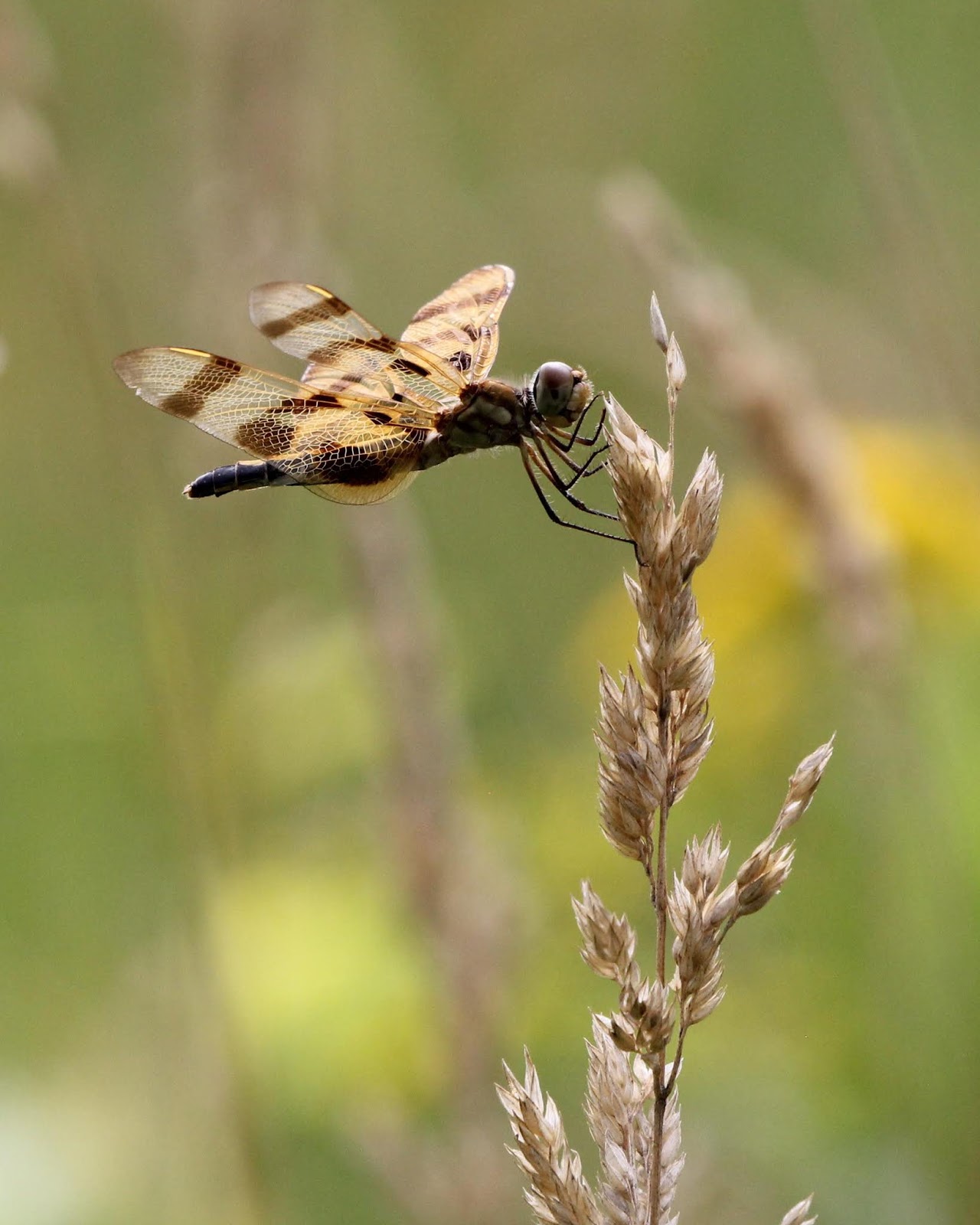
Day 42 (01 August 2018) - Halloween Pennant
This image was also photographed at Chipp-A-Waters Park. After photographing the Carolina Locust on the 31st, I noticed a Halloween Pennant (Celithemis eponina) hunting in a grassy area along the riverbank. Despite repeated attempts, I was never able to get a picture that I made me happy. I went back the next morning to try again. I actually arrived too early and had to wait for insects to begin flying. Eventually this Pennant showed up and I was able to get several photos. I cropped this from a horizontal to a vertical image. I liked the original, but I liked the vertical crop just a little bit more.
Day 43 (02 August 2018)
This picture was taken at North Higgins Lake State Park. I spent the day doing a pair of activities for a summer camp being held by the Saginaw Chippewa Indian Tribe. Due to stormy weather, we adjusted the schedule a little bit. This left me with some time before my morning activity. Although this is not the greatest image, I like the repetition of the spherical water droplets throughout the picture.
Day 44 (03 August 2018)
My final photo for the week was taken at Mission Creek Woodland Park. Although sometimes I have a plan I go out to take photos (like with the Halloween Pennant pictured above), at other times it pays to just wander and see what happens. I found these Crown Coral (Clavicorona pyxidata or Artomyces pyxidatus) growing on a rotten log in the middle of the woods. If I hadn't wandered away from the trail I never would have discovered them. Coral fungi are some of the coolest looking fungi that grow in Mid-Michigan, but I sometimes find them a challenge to photograph because they are such a start contrast to the dark wood. I decided to crop this picture as a square eliminating another clump of fungus to the left of the picture.
In the past, I have had times where I have gone days or even weeks without taking photographs. This summer I set out to change that tendency. I gave myself the task of recording images every single day between the Summer Solstice and the Fall Equinox. Not only do I need to photograph something every day, but I am also sharing a single photo from each day on this blog.
To see the previous installment (part four) check out this link.
Day 38 (28 July 2018) - Lights! Camera! Moths...
The week of 21 - 29 July was National Moth Week. In celebration, I hosted two mothing events on the nights of 27 July (for the Chippewa Watershed Conservancy) and 28 July (for the Chippewa Valley Audubon Club). This image is from the latter event at Mission Creek Woodland Park in Mt. Pleasant. This image was taken shortly after the sun went down as the moths had barely started to come in. Lots of moths were drawn to the lights, but this image was my favorite of the night.
Day 39 (29 July 2018) - Woodpecker Feather
This picture of a woodpecker flight feather was taken during a hike to the top of Bundy Hill. This feather belongs to either a Downy Woodpecker or a Hairy Woodpecker. Although these two species look very much alike, they are not closely related. The current theory is that the Downy evolved to look more like the Hairy so it wouldn't be harassed by the larger bird.
My general philosophy in regards to photo editing is that "Less is More." This picture is probably the most heavily edited image I have ever posted on this blog. It has been rotated 180 degrees from the original - I liked the quill better in the lower left of the image than in the upper right. The image has also been cropped to better focus on the feather. Even though I prefer to "crop with my feet" (move closer to the subject), I am usually okay with cropping an image down to better focus on the main subject. I have also adjusted the brightness of this image. The picture was taken in direct sunlight and the colors were rather washed out in the original.
Day 40 (30 July 2018) - Oh, Hello!
This picture of a Goldenrod Soldier Beetle (Chauliognathus pensylvanicus) on a Queen Anne's Lace (Daucus carota) was photographed at Forest Hill Nature Area. The beetle was feeding on pollen and nectar on the small individual flowers. To highlight the beetle against the sky, I lay on my back in the middle of a trail, leaned against my camera bag for support and, and aimed the camera upward. I probably shot two dozen images of this beetle as it crawled around the flower, but the pose in this picture made it my favorite. This image has been cropped slightly to reduce the amount of open space at the top and left of the picture.
Day 41 (31 July 2018) - Carolina Locust
Unlike the previous two pictures. This image has not been edited at all. I photographed this Carolina Locust (Dissosteira carolina) at Chipp-A-Waters Park in Mt. Pleasant. To get this picture I lay on a slab of limestone along the edge of the Chippewa River and focused tightly on the grasshopper. I was at the minimum focus distance for the lens on my camera. By working so close, I lost a little bit of detail on the legs, but check out the veining on the wings and the pattern on the head, thorax, and abdomen!
Day 42 (01 August 2018) - Halloween Pennant
This image was also photographed at Chipp-A-Waters Park. After photographing the Carolina Locust on the 31st, I noticed a Halloween Pennant (Celithemis eponina) hunting in a grassy area along the riverbank. Despite repeated attempts, I was never able to get a picture that I made me happy. I went back the next morning to try again. I actually arrived too early and had to wait for insects to begin flying. Eventually this Pennant showed up and I was able to get several photos. I cropped this from a horizontal to a vertical image. I liked the original, but I liked the vertical crop just a little bit more.
Day 43 (02 August 2018)
This picture was taken at North Higgins Lake State Park. I spent the day doing a pair of activities for a summer camp being held by the Saginaw Chippewa Indian Tribe. Due to stormy weather, we adjusted the schedule a little bit. This left me with some time before my morning activity. Although this is not the greatest image, I like the repetition of the spherical water droplets throughout the picture.
Day 44 (03 August 2018)
My final photo for the week was taken at Mission Creek Woodland Park. Although sometimes I have a plan I go out to take photos (like with the Halloween Pennant pictured above), at other times it pays to just wander and see what happens. I found these Crown Coral (Clavicorona pyxidata or Artomyces pyxidatus) growing on a rotten log in the middle of the woods. If I hadn't wandered away from the trail I never would have discovered them. Coral fungi are some of the coolest looking fungi that grow in Mid-Michigan, but I sometimes find them a challenge to photograph because they are such a start contrast to the dark wood. I decided to crop this picture as a square eliminating another clump of fungus to the left of the picture.
Thursday, June 21, 2018
Summer Solstice 2018
| The sun rises through the trees about twenty minutes past official sunrise. |
If you were to arise at dawn every day of the year and record the point on the horizon where the sun rises you would be able to track the progression from the Summer Solstice (in which the sun rises furthest North) to the Winter Solstice (in which the sun rises furthest South) and back again. Tracking the position of the rising sun was one of the earliest astronomical observations. Many ancient monuments were constructed to act as solar observatories, recording the longest and shortest days of the year. These observations were used to plan planting dates for various agricultural crops.
Today the sun reached its northernmost point on the horizon. Officially, at 6:07 AM EST Spring ended and Summer began in the Northern Hemisphere. This moment of change is known as the Summer Solstice. At the same time, the Southern Hemisphere was experiencing its Winter Solstice as their Fall ended and Winter began. The word solstice comes from the Latin words sol (sun) and sistere (to stand still). On the days surrounding the solstice, the sun appears to "stand still" for several days as it progresses neither north nor south along the horizon.
| Dawn atop Bundy Hill |
Today on the Summer Solstice, with the sun at its highest position in the northern sky, we celebrate our longest day of the year. With the sunrise at 5:58 AM and sunset at 9:24 PM, mid-Michigan will experience approximately 15 hours 26 minutes of daylight today. By comparison, Christchurch, New Zealand (which is approximately the same latitude south of the equator as Mid-Michigan is north of the equator), will have only 8 hours 56 minutes of sunlight today.
Why does the length of daylight vary at different locations on the globe? It has to do with three factors: rotation, revolution, and a tilt of 23.5 degrees. The Earth rotates around its axis approximately once every 24 hours. However this axis is tilted at 23.5 degrees from the vertical. The points on the globe that the axis rotates around are referred to as the North and South Poles. The axis is always pointed toward the same location in the sky. The North Pole points toward the "North Star" - Polaris.
At any given time, fifty percent of the earth is in sunlight (Day) and the other fifty percent is in darkness (Night). However, as previously mentioned, the Earth is tilted on its axis. Because of this tilt, sunlight does not always strike the Earth at the same angle. This means that during different seasons different parts of the Earth will receive varying amounts of sunlight and darkness.
As the earth revolves around the sun, sometimes the North Pole is closer to the sun, sometimes the South Pole is closer to the sun.
| A golden glow... |
When the North Pole is at its closest, the sun lights a larger portion of the Northern Hemisphere than it does the Southern Hemisphere. When this happens, we experience Summer in Mid-Michigan and the Southern Hemisphere experiences Winter. During our Northern Summer, not only does the sun light more of the Northern Hemisphere, but the sun also lights every Northern Hemisphere location for a higher percentage of the day than a comparable Southern Hemisphere location.
When the North Pole is at its furthest from the sun, we experience Winter and the Southern Hemisphere experiences Summer. During our Northern Winter, the sun is striking a larger portion of the Southern Hemisphere than it is the Northern Hemisphere, and consequently the sun lights every Southern Hemisphere location for a higher percentage of the day than a comparable Northern Hemisphere location. On two days of the year, the Spring and Fall Equinoxes, the sun lights the Northern and Southern Hemispheres equally and the length of day for will be the same for both.
So how did I celebrate the Summer Solstice? In the oldest way possible, by greeting the rising sun! I led a sunrise hike to the top of the tallest hill around. At 1276 feet above sea level, Bundy Hill is the tallest point in Isabella County. It is has been protected as a nature preserve by the Chippewa Watershed Conservancy since 2016. Unfortunately, the surrounding forest made it impossible to see the actual sunrise from atop Bundy Hill, but the trip to the top is always worth it. When the sun finally did get above the trees I was able to capture the photos seen above.
Monday, June 4, 2018
National Trails Day 2018 - A Wildflower Walk at Quigley Creek Natural Area
| I'm not always the best person to lead hikes - I tend to walk through swamps... |
Last Saturday (June 2nd) was National Trails Day. In celebration of the day, the Chippewa Watershed Conservancy hosted two events. In the morning CWC Board Member and Former Executive Director Stan Lilley led a bird walk at the Hall's Lake Preserve. In the afternoon I led an outing to search for wildflowers at Quigley Creek Natural Area. Although I think the beginning of June is sort of an in-between season for wildflowers, I was pleasantly surprised by the number of plants that we positively identified. Trees are not included in this list because we did not focus on them and only mentioned a few species in passing.
Thank you to everyone who came out and followed their guide (That would be me.) through a swamp. You were all good sports about the experience!
| A dozen people showed up to search for wildflowers. |
Now here's the list of species that we recorded.
Herbaceous Plants
Wild Geranium (Geranium maculatum)
Wild Ginger (Asarum canadense)
Feathery False Solomon's Seal (Maianthemum racemosum)
Big-leaf Aster (Eurybia macrophylla)
Moneywort (Lysimachia nummularia) - non-native
Wild Columbine (Aquilegia canadensis)
Early Meadow Rue (Thalictrum dioicum)
Golden Ragwort (Packera aurea)
Spring Avens (Geum vernum)
Swamp Buttercup (Ranunculus hispidus)
Common Black Snakeroot (Sanicula marilandica)
Jack-in-the-pulpit (Arisaema triphyllum)
Spotted Touch-me-not (Impatiens capensis)
Canada Mayflower (Maianthemum canadense)
Hog-peanut (Amphicarpaea bracteata)
Common Milkweed (Asclepias syriaca)
Wood Nettle (Laportea canadensis)
Cleavers (Galium aparine)
Virginia Creeper (Parthenocissus quinquefolia)
Marsh Marigold (Caltha palustris)
Starflower (Trientalis borealis)
Large-flowered Trillium (Trillium grandiflorum)
Bloodroot (Sanguinaria canadensis)
Swamp Saxifrage (Saxifraga pensylvanica)
Mayapple (Podophyllum peltatum)
Yellow Flag Iris (Iris pseudacorus) - non-native
| Wild Columbine |
| Wild Geranium |
| Swamp Saxifrage |
| Yellow Flag Iris - a potentially invasive species |
Ferns
Sensitive Fern (Onoclea sensibilis)
Cinnamon Fern (Osmundastrum cinnamomeum)
Northern Maidenhair Fern (Adiantum pedatum)
| Cinnamon Fern |
Shrubs
American Fly Honeysuckle (Lonicera canadensis)
Running Strawberrybush (Euonymus obovatus)
Bristly Greenbrier (Smilax hispida)
Subscribe to:
Posts (Atom)