Showing posts with label national parks. Show all posts

Monday, February 19, 2018

Happy Presidents Day 2018

Theodore Roosevelt National Park near Medora, ND

Happy Presidents Day!

My favorite U.S. President was also one of the nation's greatest champions of conservation.


North Dakota Badlands at Theodore Roosevelt National Park

Theodore Roosevelt was President of the United States from 1901 to 1909.  During his time as President, Roosevelt created designated five national parks; signed the Antiquities Act and used its powers to designate eighteen national monuments, including Devil's Tower (the nation's first) and Grand Canyon; oversaw the creation of the U.S. Forest Service and designated 150 national forests; and designated more than fifty wildlife refuges, including the nation's first at Pelican Island.  Roosevelt's conservation legacy was honored with the creation of Theodore Roosevelt National Park near Medora, ND.  Roosevelt spent parts of several years as a rancher in the area during the 1880s and much of his future conservation ethic was influenced those years.

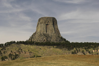
Devil's Tower was designated the nation's first National Monument in 1906.


Wednesday, July 12, 2017

Nature Geek Vacation Destination - Devil's Tower National Monument (Crook County, WY)

On Monday I wrote about how a visit to Badlands National Park left me completely awestruck.  There was one other location that we visited during our vacation that had the same effect on me - Devil's Tower National Monument.

Devil's Tower as seen from the road entering the Monument
Devils Tower a monolithic rock structure composed primarily of an igneous rock known as phonolite porphyry.  Like granite, phonolite forms when magma below the surface of the earth cools slowly allowing visible crystals to form.  Phonolite contains many of the same minerals as granite, but largely lacks quartz (a prime component of granite).  Instead, the bulk of phonolite is composed of potassium feldspars.  The phonolite at Devil's Tower is a type known as phonolite porphyry.  To say that a rock is porphyritic means that it has both small and large crystals.  At Devil's Tower, the phonolite porphyry cooled at a rate that caused it to contract and form vertical columns of hexagon rock up to 15 feet across.  These columns give the surface of Devil's Tower its unique look.

Devil's Tower - note columns of igneous rock and boulders littering its base

There are several theories of how Devil's Tower formed.  The simplest theory is that a column of magma pushed up from the earth's mantle through overlying layers of sedimentary rock.  This magma probably cooled and solidified before it broke the surface - there is no evidence to suggest it reached the surface.  Over time the layers of sedimentary rock eroded away, exposing the harder igneous rock that forms Devil's Tower.  The tower itself is slowly eroding away as evidenced by the broken boulders of phonolite porphyry scattered around its base. 

Devil's Tower rises 867 feet (265 meters) from its base to its summit.  Completely isolated from any other peaks, it rises above the surrounding prairie and pine forests.  Awesome (in the sense of causing or inspiring awe; inspiring an overwhelming feeling of reverence, admiration or fear) barely begins to describe Devil's Tower.  It is little wonder that all Native American Tribes from the region consider it a sacred place.  Many of the trees at the base of  the tower are tied with prayer bundles.

Devil's Tower - note the prayer bundles tied to the tree at the right of the image

Because of the site's sacred nature and its unique geology, in 1906 President Theodore Roosevelt used the newly passed Antiquities Act to declare Devil's Tower our nation's first national monument.  Administered by the National Park Service, Devil's Tower National Monument protects the tower and approximately 1374 acres (a little over two square miles) of surrounding prairie and Ponderosa Pine forest.

If you want to visit Devil's Tower, from Mid-Michigan it is approximately one thousand two hundred eighty mile (or nearly nineteen hours) of driving away.  Obviously, this is not a weekend trip, but when combined with other sites such as the Badlands and Black Hills this is a can't miss vacation destination for any nature geek!

If you do choose to travel to Devil's Tower, here's a little hint:  the best views of the tower are not the one's you get by visiting the base of the tower.  The base of the tower is crowded, with approximately 400,000 visitors each year.  Do yourself a favor and after leaving the visitor center parking lot, turn onto a gravel road that lead to the Joyner Ridge Trail.  This road lead to a gravel parking lot about one mile northwest of Devil's Tower.  When we arrived there, there were only two other cars in the lot.  Here is the view you are rewarded with...


Here are a few more Devil's Tower photos from the Joyner Ridge trailhead.  I like how the clouds in these images look like a puff of smoke coming out of the Tower.  Enjoy.


This final picture is probably my favorite on of Devil's Tower with the lone Ponderosa Pine, grasses, and the Tower off in the distance surrounded by more pines.


Monday, July 10, 2017

Nature Geek Vacation Destination - Badlands National Park (Interior, SD)

awesome
adj.
Causing or inspiring awe; inspiring an overwhelming feeling of reverence, admiration or fear

awful (archaic)
adj.
inspiring reverential wonder or fear

awestruck
adj.
filled with or revealing awe


The word awesome is overused.  People use it when they mean something is good.  For instance, someone might say their strawberry-banana-kale-chia smoothie is "Awesome!"  Or a waiter at a restaurant my respond to my order of nachos with "Awesome!"

I just returned from a two week vacation.  Shara and I drove three thousand eight hundred miles and visited nine states.  In that time I saw two places that I could literally describe as awesome in the sense that they inspired an overwhelming feeling of reverence, admiration, or fear.  The first of these places was the Badlands of South Dakota.  The Badlands are a place of truly awful (inspiring reverential wonder or fear) beauty.  Shara commented while were standing on an overlook that she felt very insignificant - that is a very good thing to say about the Badlands. I have no words to describe them - I was literally awestruck by their grandeur.

The Badlands were formed by two geologic processes, deposition and erosion.  Over the course of tens of millions of years layers of sediment (sand, mud, volcanic ash, etc.) were deposited in the area that is today known as the Badlands.  For the past approximately 500,000 years wind and water have been eroding those sediments, creating the gullies, hills, and outcrops that we see today.  Geologists predict that in another 500,000 years the Badlands will be completely eroded away.  For more information on the Geology of Badlands Nation Park please visit this National Park Service webpage

Although photographs cannot do the Badland justice, here are a few of hundreds of pictures that I took during our visit.  If you want to visit the Badlands, they are almost due west of Mid-Michigan approximately one thousand one hundred miles (or sixteen hours) of driving away.  From the Badlands it is only another ninety minutes of driving to the Black Hills area (more on this later).

For now, here are my Badlands photos.  Enjoy.

Thursday, August 25, 2016

Happy Birthday to the National Park Service!

Happy birthday to you,
Happy birthday dear National Park Service,
Happy birthday to you!

Today marks the 100th birthday of America's National Park Service.  Although the first national park (Yellowstone) was created in 1872, the National Park Service was not created until 25 August 1916.

The National Park Service currently manages over 400 different units of land across the United States; including 59 National Parks, dozens of National Monuments, Preserves, Historical Parks and Sites, Battlefields, Military Parks, Memorials, etc.

Michigan is home to five official National Park Service units:  Isle Royal National Park, Keweenaw National Historical Park, Pictured Rocks National Lakeshore, Sleeping Bear Dunes National Lakeshore, and the River Raisin National Battlefield Park.  The state is also home to a portion of the North Country National Scenic Trail and the Motor Cities National Heritage Area.


Wednesday, July 27, 2016

Nature Geek Vacation Destinations - Mammoth Cave National Park (Mammoth Cave, KY)

It's been a while since there has been a new post on this blog.  Regular visitors to this site will probably notice a pattern.  I try to publish new posts every week day during the school year and at least three times a week during the summer.  However, every year (typically in July), this site goes dark for a week or two while Shara and I go on vacation.  This year's trip took us south through Ohio, into Kentucky, and back up through Indiana, Illinois, and into Iowa before returning home to Michigan.

We typically do lots of "science geek" and "history geek" things on our vacations - visiting museums, nature centers, public gardens, historic sites, etc..  Over the next few posts I plan on sharing a few of the highlights.


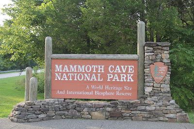
One of the stops on our trip was at Mammoth Cave National Park.  Mammoth Cave is the world's largest cave system.  Currently four hundred five (405) miles of interconnecting passages have been mapped! 


Much of the bedrock in Kentucky consists of layers of either sandstone, shale, or limestone. Mammoth Cave (any many other caves found in Kentucky) formed as a result of flowing water dissolving layers of limestone and leaving the shale and sandstone layers behind.  Many  features in the caves (stalactites, stalagmites, flowstones, soda straws, etc.) form as dissolved minerals in the water are deposited on the ceiling, walls, or floor of the cave.

The National Park Service offers a number of tours in the cave.  The tours range in distance from 1/4 mile to 5 miles, and vary in time from 1.25 hours to 6 hours in length.  We chose to take one of the shortest options - the Frozen Niagara Tour.  This tour takes place at an entrance to the cave system that was created in 1924 to provide easy access to this portion of the cave. 

Visitors to the cave are not alone.  Other species either live in the caves or use the caves as shelter.  Species include eyeless cave fish that are adapted to life in the dark, cave salamanders, cave crayfish, cave crickets, Allegheny Wood Rats (also known as "pack rats"), and bats.  The bats hibernate in the cave and are mostly absent during the summer months.

An Allegheny Wood Rat nest illuminated by our guide's flashlight - the things on the ceiling are cave crickets

Cave crickets!

While the animals are cool, the focus of the tour is on the unique geologic features.


Visitors to the cave are asked to not use touch any of the cave's surfaces.  Natural oils from human skin can actually disrupt (and stop) the process of mineral deposition.  In the past, before the cave became a national park, visitors were allowed to write their name on the ceiling of some portions of the cave.  While this "historic graffiti" is preserved, anyone that does this today will be given a hefty fine and potentially receive jail time.

Humans can have another catastrophic effect on the caves.  We are a major cause for the spread of White Nose Syndrome.  This fungal disease has killed millions of hibernating bats across eastern North America.  Humans spread the disease by visiting caves that are infected and then failing to properly decontaminate before visiting other caverns.  The spores from the fungus travel along with us and infect bats in the new cave.  After leaving Mammoth Cave, visitors are required to walk across disinfecting mats to treat their shoes with a fungicide.

Shara in her #Save the Bats t-shirt from the Organization for Bat Conservation

Mammoth Cave is located about eight hours from Mid-Michigan and could easily be visited during a long weekend excursion.  If you want to take one of the cave tours it is recommended that you reserve a space on the tour ahead of time - some of the tours sell out.

I don't have a cool #Save the Bats t-shirt (yet)

Monday, January 26, 2015

Field Trip - Munising, Michigan

Located along the southern shore of Lake Superior in Michigan's Upper Peninsula, Munising is approximately 4 1/2 hours from Mid-Michigan.  This means that Munising is realistically outside the range of a day-trip, but it does make a good weekend destination.

So why go to Munising?

Rocks and water.

The Lake Superior shoreline to the east of Munising is designated as Pictured Rocks National Lakeshore.

Some of the Lakeshore's cliffs and eroded sandstone features can be seen from shore, but they are best viewed from the water.

Miners Castle viewed from the shoreline - one of the two spires on this feature has since collapsed

Looking down at the lake from the top of the cliffs
 
This can be done from a private boat or sea kayak, or you can book passage on a tour boat operated by Pictured Rocks Cruises - 2014 prices were $36 for an adult with tickets for children ages 6 -12 priced at $10.

A sea kayaker paddling along the cliffs
 
Miners Castle viewed from the lake

If possible, take the sunset cruise for the best light.  The cruise takes you close along towering cliffs.


Pictured Rocks viewed from a tour boat

The low evening sun enhances the colors of the Pictured Rocks


Immediately north of Munising is Grand Island.  Grand Island, divides and protects the entrance to the Munising Bay.  The waters around Munising can be hazardous and two lighthouses were erected to guide ships into the bay.  At least 30 ships have sunk while trying to enter the bay.  Two boats operated by Munising's Glass Bottom Shipwreck Tours will take you to see several of these wrecks located in the east arm of the bay.  Tickets for these tours are $32 for adults and $12 for children aged 6 to 12.

East Grand Island Light

A portion of one of the Munising shipwrecks

Mature Bald Eagle on Grand Island

Rock and water also meet in the many waterfalls that can be found around Munising.  More than a dozen waterfalls can be found either within the boundaries of Pictured Rocks National lakeshore or on public or private land nearby.  Several of these waterfalls can be seen from the roadside or located just a short walk away.  A few are best viewed from out in Lake Superior.

Wagner Falls is located in a park just south of Munising

Scott Falls is located along the roadside west of Munising

Spray Falls viewed from tour boat

One feature of Munising that is rarely talked about is its relatively unpolluted night sky.  These photos were taken from a hotel balcony, the view from a few miles outside of town should be even better.

The northern sky from Munising

The same view enhanced to show faint curtains of the Northern Lights


Thursday, January 23, 2014

Geology Concepts - Cross-bedding

Continuing with the geology theme...

Yesterday I wrote about the geologic principle of Original Horizontality.  This is the idea that the sediments that formed sedimentary rocks were originally deposited horizontally, even if the rocks are no longer in a horizontal position.  These horizontal layers are known as beds. These beds are typically found over wide areas and are uniformly thick.

However, sometimes the sediments within those beds are not laid down evenly in a horizontal layers.  The sediments within a bed may be laid down in inclined layers.  This process is known as Cross-bedding.  Cross-bedding happens when sediment is moved by water (or wind) currents.  Cross-bedding is often found in dunes, ripples, and sand/gravel bars.  Cross-bedding in sedimentary rock provides evidence of past currents preserved in stone.

Looking at a photo from Pictured Rocks National Lakeshore, most of the beds found in the exposed sandstone are horizontal, just as they were originally deposited.  There are several beds in which the sediments were not deposited horizontally.  These beds show cross-bedding and are evidence of currents moving the sediments around.

Sandstone beds at Pictured Rocks National Lakeshore - Can you find the cross-bedding?

The next image is the same photograph with some of the cross-bedding indicated by tilted yellow lines.  If you look closely, there are several more areas of cross-bedding that I have not marked.

Sandstone beds at Pictured Rocks National Lakeshore - areas of cross-bedding are indicated by diagonal lines
The next photograph is another image of sandstone deposits at Pictured Rocks National Lakeshore.  The horizontal beds are easily visible, as is one section of cross-bedding.

Horizontal and cross-bedding at Pictured Rocks National Lakeshore

Here is the same photograph with the cross-bedding outlined. 

Sandstone formation at Pictured Rocks National Lakeshore - area of cross-bedding outlined
The above photographs are taken at Pictured Rocks National Lakeshore.  Pictured Rocks is located in Michigan's Upper Peninsula along the southern shore of Lake Superior.  This is about a 4 1/2 hour drive from Mid-Michigan. 

Why didn't I just use photos of a rock formation from Mid-Michigan instead?

There is no surface bedrock to be found in Mid-Michigan.  Most of the bedrock in Michigan is covered by glacial deposits of sand, gravel, and rock.  These deposits range from a few inches in some area to up to 1200 feet.  The State of Michigan estimates that the average depth of glacial deposits in Michigan is 300 feet!

Tuesday, September 10, 2013

More of Sleeping Bear Dunes National Lakeshore

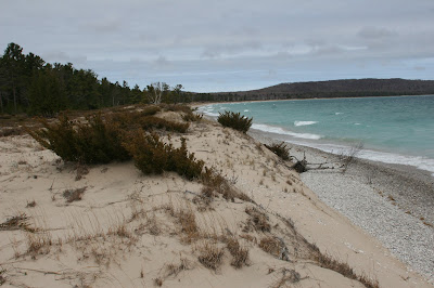
I thought today that I would post a few more images that I have taken at Sleeping Bear Dunes National Lakeshore over the past six years.  These photos were taken at different locations (including Pierce Stocking Scenic Drive, North Manitou Island, and the Port Oneida Rural Historical District) at times of the year ranging from Spring to Fall.  Enjoy.