Showing posts with label rocks. Show all posts

Tuesday, October 23, 2018

Upcoming Event - 2018 Mid-Michigan Rock Club Annual Show and Sale (03 - 04 November 2018)


On Saturday November 3rd and Sunday November 4th, the Mid-Michigan Rock Club will be hosting its 25th Annual Rock Show at the Chippewa Nature Center at 400 S. Badour Rd, Midland MI.

The show is open 10:00AM to 5:00PM on both Saturday and Sunday.  Admission to the 2018 show is FREE!

If you are a rock hound or an aspiring rock hound be sure to attend.  This is a great way to add to your collection.  In addition to the regular vendors, the Mid-Michigan Rock Club always has a selection of low-priced rock and mineral samples that can be used to build a beginner's rock collection.  Over the past several years we have constructed beginner rock kits for several nieces and nephews from rocks purchased at this sale.

Also be sure to attend one of the presentations offered during the show.  Presentation topics include Petoskey stones, beach rock identification, and fossils.  For a full list of presentations and more details about the event please visit the Mid-Michigan Rock Club website.

Wednesday, October 17, 2018

Get your Earth Science Week Geek On!

Happy Earth Science Week 2018!

Earth Science Week is an annual week-long celebration of everything earth science.  This celebration is sponsored the American Geosciences Institute.

When you think of exciting earth science locations, Michigan doesn't immediately spring to mind.  That doesn't mean that there isn't a lot to see.

Here are five of my favorite locations in Michigan.

Sleeping Bear Dunes National Lakeshore


Located in the northwest part of the Lower Peninsula, Sleeping Bear Dunes National Lakeshore is probably the best place to see sand dunes anywhere along the Great Lakes shorelines.  These dunes have built up since the end of the last glacial maximum (ice age) and now soar hundreds of feet above the surface of Lake Michigan.  The dunes are not the only attraction - Sleeping Bear dunes also has dozens of miles of hiking trails, some of the best spring wildflowers in the state, and two islands to explore (North and South Manitou).

Pictured Rocks National Lakeshore


If Sleeping Bear Dunes is all about sand, Pictured Rocks National Lakeshore is all about sandstone.  The geologic formation of Pictured Rocks dates back more than 500 million years.  While you can enjoy the Pictured Rocks from land, they are best seen from the water.  Located along the shoreline of Lake Superior near Munising, MI Pictured Rocks National Lakeshore is too far away from Mid-Michigan for a day trip, but can easily be visited during a long weekend.  Not only are there giant sandstone cliffs, but the Lakeshore is home to several spectacular waterfalls and the largest dunes on Lake Superior (Grand Sable Dunes).

Lake of the Clouds, Porcupine Mountains Wilderness State Park


Porcupine Mountains State Park is located near the west end of the Upper Peninsula along the shore of Lake Superior.  The valley that holds Lake of the Clouds was carved out by glaciers from rock dating as much as 1.1 billion years old.  This rock can best be seen from the Lake of the Clouds overlook on the Carp River Escarpment.


As a bonus, this area is home to several fault lines - places where plates of the earth's crust contact each other.  One of these faults can be seen at nearby Bonanza Falls, where the Big Iron river crosses over a tilted layer of Nonesuch Shale.  Bonanza falls is located just east of the park boundary near Silver City, MI.

If you visit the Porcupine Mountains take the time to drive up the nearby Keweenaw Peninsula to visit the A.E. Seaman Mineral Museum at Michigan Technological University.  It's a geology nerd destination in its own right.

Muskallonge Lake State Park


To me Muskallonge Lake State Park is the best place in Michigan to pick up rocks.  The park is located in the eastern Upper Peninsula, tucked between the shore or Lake Superior and inland Muskallonge Lake.  The shoreline of Lake Superior is a rock beach - with new rocks being constantly driven up by waves from the lake this is a rockhunters dream.  I find it impossible to leave with out pockets full of rocks.  Everyone is looking for agates, but some of the igneous rocks are just as beautiful!

As a bonus, Muskallonge Lake has some of the best stargazing I have ever experienced.  We lay on a picnic table watching the stars at 2:00AM for nearly an hour during our last visit to the park.

Bundy Hill Preserve


I hate to say it, but Mid-Michigan is not the best location for geology nerds.  Our rock formations are buried under hundreds of feet of glacial till.  If you can't beat the glacial deposits, you might as well enjoy them!  Bundy Hill is the highest point in Isabella County.  At 500 feet higher than the nearby town of Mt. Pleasant, Bundy Hill is a moraine, formed where two glacial lobes came together, piling sand and rock between them.  Owned by the Chippewa Watershed Conservancy, Bundy Hill is accessible to the public and has two miles of brand new hiking trails.  If you go, make sure to take a picture of the summit marker and search for the large boulders (glacial erratics) that dot the site.  One of these boulders, located near the summit is nearly 40 feet around!

Monday, August 13, 2018

The Days of Summer - Day Forty-five through Day Fifty-one

This is part seven of my Days of Summer photography project.   Beginning with the Summer Solstice (21 June 2018) and ending with the Fall Equinox (22 September 2018), I am making it a point to get outdoors and photograph something every single day.  One photograph from each day is being selected for this project and shared here.

The previous installments of this project can be found at the links below:

Part Six
Part Five
Part Four
Part Three
Part Two
Part One

I hope you enjoy the photos from this past week - one of them might be quite a surprise.

Day 45 (04 August 2018) - A Banded Bird


The first image of the week was taken at Forest Hill Nature Area.  If you look closely at This female Common Yellowthroat (Geothlypis trichas) you might notice that her left leg sports a band.  Between this picture and several others of this bird I was able to make out a couple numbers on the band.  With that information, I contacted Mike Bishop at Alma College - he is running a banding project at Forest Hill.  With the numbers I gave him, Mike was able to narrow it down to one of two birds that he banded on June 28th of this year.  We both thought this was pretty cool.

This photograph has been cropped into a landscape format - taking some off the top and bottom of the image.  I just thought it was the most appealing of all the different crops that I tried.  I like how the bird looks like she is about the launch herself at the goldenrod to the left of the image.

Monday, October 30, 2017

Visiting four CWC preserves in one day (Part One)

The Chippewa Watershed Conservancy currently own twenty-two preserves scattered across four counties.  Yesterday (29 October 2017) I visited the four "flagships" of the CWC's preserve system - Sylvan Solace Preserve, Bundy Hill Preserve, Hall's Lake Natural Area, and Audubon Woods Preserve.  The close nature of three out of these four preserves made it easy to link my visits together.  My goal was simply to visit each of the four preserves, walk on and off trail, and photograph whatever grabbed my attention.  Because I took so many photos I am going to split this into two posts.  This post will deal with my visits to Sylvan Solace Preserve and Bundy Hill Preserve.

Sylvan Solace Preserve


Sylvan Solace Preserve was my first stop.  This preserve is located on Pickard Road, between Gilmore and Littlefield Roads, approximately 7 1/2 miles west of Mt. Pleasant.  I arrived at Sylvan Solace just a few minutes after 9:00AM and spent about approximately 1.5 hours on site.

Here are a few of the many photos that I took during that time.

A deer trail through a grove of Black Locust trees.

A dead pine slowly succumbs to rot, insects, and woodpeckers.

Ferns change into their subtle shades of red, orange, and brown.

Small metal arrows mark the location and direction of trails throughout the preserve

Looking up at the overcast sky through Bigtooth Aspen trees.

Bigtooth Aspen leaves turn yellow then brown as they dry out.

Along the east trail at Sylvan Solace, I noticed several scrapes made by White-tailed Deer.   Scrapes are one of the ways White-tailed bucks leave scent to mark their territory.  Located above the scrape is typically a low-hanging branch that the buck will lick and rub with the scent glands located on his head.  The buck scrapes the ground with its hooves to draw attention to the scent marker and typically urinates on the scrape to add even more scent.  Both bucks and does will check out scrapes.  Although bucks create scrapes year-round, this behavior intensifies in the weeks before mating season.  I found several fresh scrapes at Sylvan Solace and would go on to find scrapes at each of the other three preserves I visited.

A fresh deer scrape is used to leave a scent "calling card" to announce a buck's presence in the area.

A mushroom pokes up from the leaf litter.

Looking upstream at Sylvan Solace Preserve.

Spreading oak trees grew up in the open before being surrounded by forest.

American Beech trees will be among the last to lose their leaves - often holding them through mid-winter.

Nest boxes provide artificial cavities used by many bird species.

A fern, grasses, and Bigtooth Aspen leaves create a colorful mosaic.

Rain and dewdrops bead up on the waxy coating of freshly-fallen Aspen leaves.

The pictures of my second preserve visit can be seen below.

Wednesday, October 25, 2017

Red Oak leaf (May 2009)

Red Oak leaf and beach rocks (07 May 2009)

I took this photograph on 07 May 2009 at the mouth of the Platte River in Benzie County, MI.  I came across this picture yesterday while backing up files to an external hard drive.

Sometimes I look at pictures that I took nearly a decade ago and those that I took this year and I wonder if my photography skills have improved at all. 

Monday, October 16, 2017

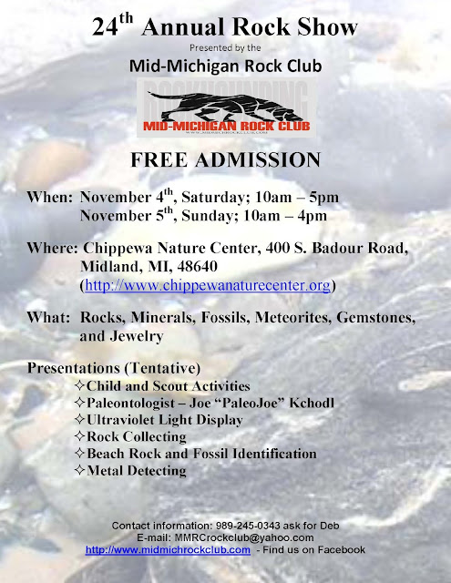
Upcoming Event - 2017 Mid-Michigan Rock Club Annual Show (04 - 05 NOV 2017)


On Saturday November 4th and Sunday November 5th, the Mid-Michigan Rock Club will be hosting its 24th Annual Rock Show at the Chippewa Nature Center at 400 S. Badour Rd, Midland MI.

The show is open 10:00AM to 5:00PM on Saturday (04 NOV) and 10:00AM to 4:00PM on Sunday (05 NOV).  Admission to the 2017 show is FREE!

While the show is being held at a new location this year, it actually represents a return to the past.  The first several Mid-Michigan Rock Club shows that I attended were held at the Chippewa Nature Center.  Over the past few years, the show has moved to a couple different locations, before returning back to the CNC for this 2017.


If you are a rock hound or an aspiring rock hound be sure to attend.  This is a great way to add to your collection.  In addition to the regular vendors, the Mid-Michigan Rock Club always has a selection of low-priced rock and mineral samples that can be used to build a beginner's rock collection.  Over the past several years we have constructed beginner rock kits for several nieces and nephews from rocks purchased at this sale.

Tuesday, October 10, 2017

Earth Science Week 2017 - Tuesday

Happy Earth Science Week 2017!

Of the four disciplines included in earth science, geology is my favorite.  Mid-Michigan does not have many interesting geological features so whenever we go on vacation we try to see any unique features that are near our destination.  This summer our vacation took us west to North and South Dakota (and places in between).  I have already shared pictures of Custer State Park, Badlands National Park, and Devil's Tower National Monument.  Now I want to share a few pics from two other destinations.

First up is a feature known as "The Castles".  This limestone feature is found in the Custer National Forest  near Reva, SD.  It is listed as a National Natural Landmark by the National Park Service.


My favorite feature of these rocks is the tilted beds of limestone seen in the next image.  It's pretty amazing to think that these beds would have originally been deposited horizontally, then tilted, partially eroded, and then overlain with more horizontal layers of rock.


The next set of images comes from our visit to the South Unit of Theodore Roosevelt National Park near Medora, SD.  This unit of the park centers on an area known as the North Dakota Badlands.  While not as monumental as the Badlands of South Dakota, the scenery is still spectacular.


Thursday, October 13, 2016

Earth Science Week 2016 - The rocks on my desk...

Happy Earth Science Week!

For today, I just thought I would photograph and share the rocks that are currently sitting on my desk at the office.  This doesn't include the ones in the desk, or the ones in a box under the desk, or the ones on a shelf next to the desk, or the ones...

Well you get the idea - there are a lot of rock samples around my desk.

Unakite pebble - pink feldspar, clear quartz, and green epidote

Chain coral fossil

Chert - a form of micro-crystalline quartz

Concretion (?)

Slate

Not sure on this one...

Conglomerate - AKA "puddingstone"
 
Limestone with horn coral fossil
 
Limestone with bryozoa fossil
 
Not sure what to call this one - looks like fractured basalt with quartz bonding it together

Petrified wood slices
 
Possibly Limonite - a form of iron ore


I'm not sure of the origins of all of these rocks.  I collected some of them, others were given to me, and others were purchased at rock shows/rock shops/etc.

I'm also not entirely sure why they are all sitting on my desk.  I'm sure there are very good reason, but I can't think of them right now.  I need to clean my desk...