Last week I mentioned that we made a return visit to the International Crane Foundation (ICF) near Baraboo, WI. I wrote a long post about ICF after our first visit so I'm not going to say much about it today except to say that if you are ever in central Wisconsin near the towns of Wisconsin Dells or Baraboo you should definitely visit! Need convincing? Here are a few photos from our recent visit.
First up was the Grey Crowned Crane (Balearica regulorum). This African species is currently listed as endangered by the International Union for Conservation of Nature (IUCN).
The next photo is of a Wattled Crane (Bugeranus carunculatus). Another African crane species, the Wattled Crane is listed as Vulnerable by IUCN. It's population seems to be trending downward.
The final three crane photos are of North America's tallest bird the Whooping Crane (Grus americana). This species is listed as Endangered by the IUCN. Population estimates in 2016-17 list this species at less than 500 wild birds up from a population of only 15 adults in 1938! During our previous Wisconsin trip in 2015 we were lucky enough to see one of the approximately 100 wild Whoopers that call Wisconsin home.
These are only three of the ten species that we saw. The International Crane Foundation houses all fifteen of the world's crane species, but on both of our visits we have only managed to see ten species each time. The final three three pics are of a sculpture on the path to the Whooping Crane exhibit. This sculpture represents a single crane taking flight.
Showing posts with label vacation. Show all posts
Monday, July 2, 2018
Tuesday, October 10, 2017
Earth Science Week 2017 - Tuesday
Happy Earth Science Week 2017!
Of the four disciplines included in earth science, geology is my favorite. Mid-Michigan does not have many interesting geological features so whenever we go on vacation we try to see any unique features that are near our destination. This summer our vacation took us west to North and South Dakota (and places in between). I have already shared pictures of Custer State Park, Badlands National Park, and Devil's Tower National Monument. Now I want to share a few pics from two other destinations.
First up is a feature known as "The Castles". This limestone feature is found in the Custer National Forest near Reva, SD. It is listed as a National Natural Landmark by the National Park Service.
My favorite feature of these rocks is the tilted beds of limestone seen in the next image. It's pretty amazing to think that these beds would have originally been deposited horizontally, then tilted, partially eroded, and then overlain with more horizontal layers of rock.
The next set of images comes from our visit to the South Unit of Theodore Roosevelt National Park near Medora, SD. This unit of the park centers on an area known as the North Dakota Badlands. While not as monumental as the Badlands of South Dakota, the scenery is still spectacular.
Of the four disciplines included in earth science, geology is my favorite. Mid-Michigan does not have many interesting geological features so whenever we go on vacation we try to see any unique features that are near our destination. This summer our vacation took us west to North and South Dakota (and places in between). I have already shared pictures of Custer State Park, Badlands National Park, and Devil's Tower National Monument. Now I want to share a few pics from two other destinations.
First up is a feature known as "The Castles". This limestone feature is found in the Custer National Forest near Reva, SD. It is listed as a National Natural Landmark by the National Park Service.
My favorite feature of these rocks is the tilted beds of limestone seen in the next image. It's pretty amazing to think that these beds would have originally been deposited horizontally, then tilted, partially eroded, and then overlain with more horizontal layers of rock.
The next set of images comes from our visit to the South Unit of Theodore Roosevelt National Park near Medora, SD. This unit of the park centers on an area known as the North Dakota Badlands. While not as monumental as the Badlands of South Dakota, the scenery is still spectacular.
Thursday, August 17, 2017
Nature Geek Vacation Destinations - Custer State Park, Custer, SD
One of the highlights of our recent vacation in South Dakota was a pair of visits to Custer State Park. Our first visit to Custer State Park was preceded by a trip to Mt. Rushmore National Monument. From Mt. Rushmore, the shortest route into Custer State Park is US Route 16A. Also known as Iron Mountain Road, this route passes through three tunnels and multiple switchbacks and loops that frame views of Mt. Rushmore. There are also several scenic turnouts and parking areas that allow you to see panoramic views of the Black Hills and the plains to the east of the park.
At the eastern edge of the park Route 16A joins up with South Dakota Highway 36. SD 36 will lead you east out of the park. If you continue west on 16A, you will need to purchase a South Dakota State Park entrance permit. As of July 2017, annual permits cost $30; Custer State Park also offers the option of a 7-day pass for $20. We chose to purchase the 7-day pass as we did not intend to visit any other South Dakota State Park. A short drive from the entrance gate is the east end of the park's Wildlife Loop Road.
Wednesday, July 12, 2017
Nature Geek Vacation Destination - Devil's Tower National Monument (Crook County, WY)
On Monday I wrote about how a visit to Badlands National Park left me completely awestruck. There was one other location that we visited during our vacation that had the same effect on me - Devil's Tower National Monument.
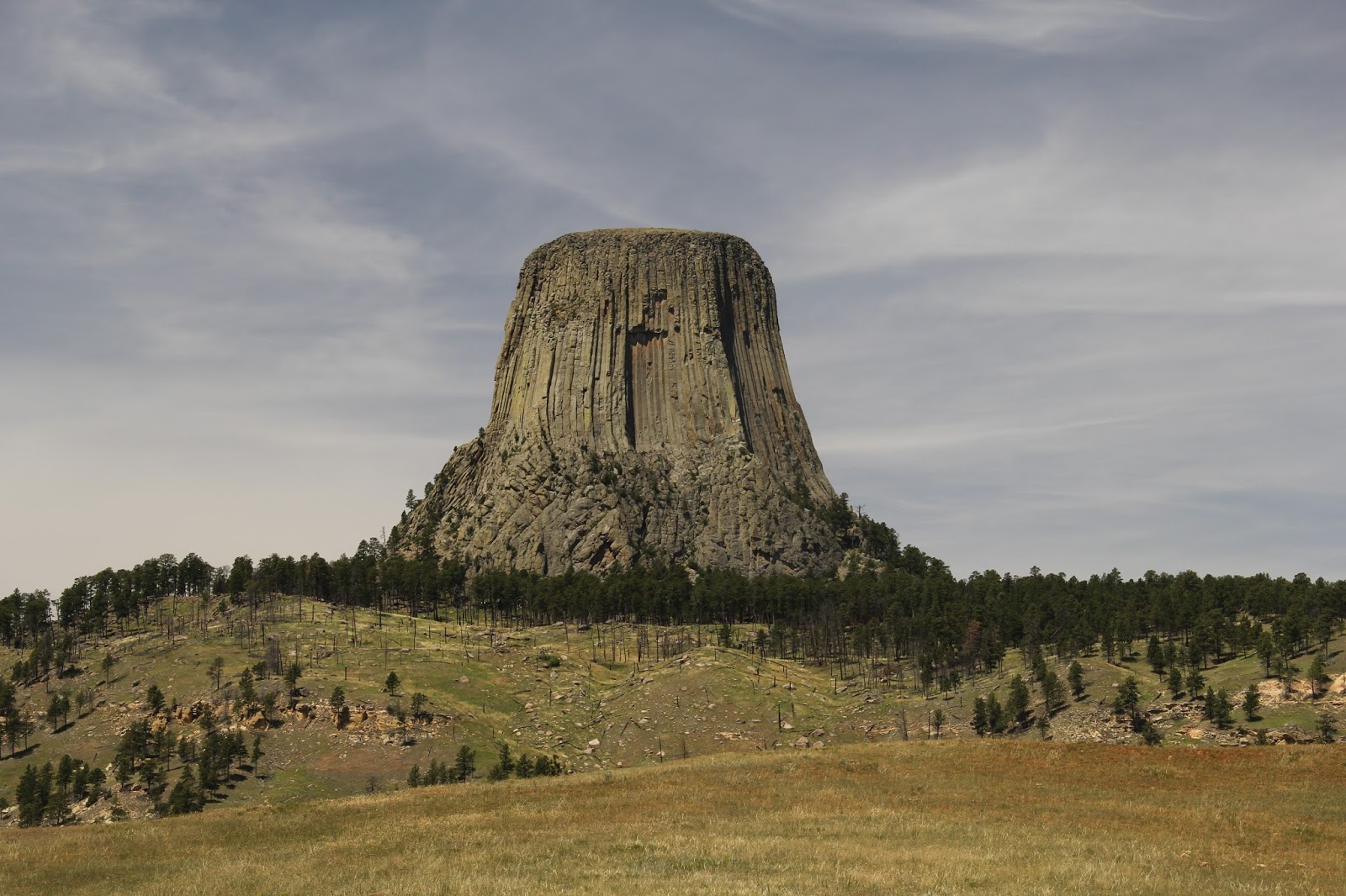
Devils Tower a monolithic rock structure composed primarily of an igneous rock known as phonolite porphyry. Like granite, phonolite forms when magma below the surface of the earth cools slowly allowing visible crystals to form. Phonolite contains many of the same minerals as granite, but largely lacks quartz (a prime component of granite). Instead, the bulk of phonolite is composed of potassium feldspars. The phonolite at Devil's Tower is a type known as phonolite porphyry. To say that a rock is porphyritic means that it has both small and large crystals. At Devil's Tower, the phonolite porphyry cooled at a rate that caused it to contract and form vertical columns of hexagon rock up to 15 feet across. These columns give the surface of Devil's Tower its unique look.
There are several theories of how Devil's Tower formed. The simplest theory is that a column of magma pushed up from the earth's mantle through overlying layers of sedimentary rock. This magma probably cooled and solidified before it broke the surface - there is no evidence to suggest it reached the surface. Over time the layers of sedimentary rock eroded away, exposing the harder igneous rock that forms Devil's Tower. The tower itself is slowly eroding away as evidenced by the broken boulders of phonolite porphyry scattered around its base.
Devil's Tower rises 867 feet (265 meters) from its base to its summit. Completely isolated from any other peaks, it rises above the surrounding prairie and pine forests. Awesome (in the sense of causing or inspiring awe; inspiring an overwhelming feeling of reverence, admiration or fear) barely begins to describe Devil's Tower. It is little wonder that all Native American Tribes from the region consider it a sacred place. Many of the trees at the base of the tower are tied with prayer bundles.
Because of the site's sacred nature and its unique geology, in 1906 President Theodore Roosevelt used the newly passed Antiquities Act to declare Devil's Tower our nation's first national monument. Administered by the National Park Service, Devil's Tower National Monument protects the tower and approximately 1374 acres (a little over two square miles) of surrounding prairie and Ponderosa Pine forest.
If you want to visit Devil's Tower, from Mid-Michigan it is approximately one thousand two hundred eighty mile (or nearly nineteen hours) of driving away. Obviously, this is not a weekend trip, but when combined with other sites such as the Badlands and Black Hills this is a can't miss vacation destination for any nature geek!
If you do choose to travel to Devil's Tower, here's a little hint: the best views of the tower are not the one's you get by visiting the base of the tower. The base of the tower is crowded, with approximately 400,000 visitors each year. Do yourself a favor and after leaving the visitor center parking lot, turn onto a gravel road that lead to the Joyner Ridge Trail. This road lead to a gravel parking lot about one mile northwest of Devil's Tower. When we arrived there, there were only two other cars in the lot. Here is the view you are rewarded with...
Here are a few more Devil's Tower photos from the Joyner Ridge trailhead. I like how the clouds in these images look like a puff of smoke coming out of the Tower. Enjoy.
This final picture is probably my favorite on of Devil's Tower with the lone Ponderosa Pine, grasses, and the Tower off in the distance surrounded by more pines.
| Devil's Tower as seen from the road entering the Monument |
| Devil's Tower - note columns of igneous rock and boulders littering its base |
There are several theories of how Devil's Tower formed. The simplest theory is that a column of magma pushed up from the earth's mantle through overlying layers of sedimentary rock. This magma probably cooled and solidified before it broke the surface - there is no evidence to suggest it reached the surface. Over time the layers of sedimentary rock eroded away, exposing the harder igneous rock that forms Devil's Tower. The tower itself is slowly eroding away as evidenced by the broken boulders of phonolite porphyry scattered around its base.
Devil's Tower rises 867 feet (265 meters) from its base to its summit. Completely isolated from any other peaks, it rises above the surrounding prairie and pine forests. Awesome (in the sense of causing or inspiring awe; inspiring an overwhelming feeling of reverence, admiration or fear) barely begins to describe Devil's Tower. It is little wonder that all Native American Tribes from the region consider it a sacred place. Many of the trees at the base of the tower are tied with prayer bundles.
| Devil's Tower - note the prayer bundles tied to the tree at the right of the image |
Because of the site's sacred nature and its unique geology, in 1906 President Theodore Roosevelt used the newly passed Antiquities Act to declare Devil's Tower our nation's first national monument. Administered by the National Park Service, Devil's Tower National Monument protects the tower and approximately 1374 acres (a little over two square miles) of surrounding prairie and Ponderosa Pine forest.
If you want to visit Devil's Tower, from Mid-Michigan it is approximately one thousand two hundred eighty mile (or nearly nineteen hours) of driving away. Obviously, this is not a weekend trip, but when combined with other sites such as the Badlands and Black Hills this is a can't miss vacation destination for any nature geek!
If you do choose to travel to Devil's Tower, here's a little hint: the best views of the tower are not the one's you get by visiting the base of the tower. The base of the tower is crowded, with approximately 400,000 visitors each year. Do yourself a favor and after leaving the visitor center parking lot, turn onto a gravel road that lead to the Joyner Ridge Trail. This road lead to a gravel parking lot about one mile northwest of Devil's Tower. When we arrived there, there were only two other cars in the lot. Here is the view you are rewarded with...
Here are a few more Devil's Tower photos from the Joyner Ridge trailhead. I like how the clouds in these images look like a puff of smoke coming out of the Tower. Enjoy.
This final picture is probably my favorite on of Devil's Tower with the lone Ponderosa Pine, grasses, and the Tower off in the distance surrounded by more pines.
Monday, July 10, 2017
Nature Geek Vacation Destination - Badlands National Park (Interior, SD)
awesome
adj.
Causing or inspiring awe; inspiring an overwhelming feeling of reverence, admiration or fear
awful (archaic)
adj.
inspiring reverential wonder or fear
awestruck
adj.
filled with or revealing awe
The word awesome is overused. People use it when they mean something is good. For instance, someone might say their strawberry-banana-kale-chia smoothie is "Awesome!" Or a waiter at a restaurant my respond to my order of nachos with "Awesome!"
I just returned from a two week vacation. Shara and I drove three thousand eight hundred miles and visited nine states. In that time I saw two places that I could literally describe as awesome in the sense that they inspired an overwhelming feeling of reverence, admiration, or fear. The first of these places was the Badlands of South Dakota. The Badlands are a place of truly awful (inspiring reverential wonder or fear) beauty. Shara commented while were standing on an overlook that she felt very insignificant - that is a very good thing to say about the Badlands. I have no words to describe them - I was literally awestruck by their grandeur.
The Badlands were formed by two geologic processes, deposition and erosion. Over the course of tens of millions of years layers of sediment (sand, mud, volcanic ash, etc.) were deposited in the area that is today known as the Badlands. For the past approximately 500,000 years wind and water have been eroding those sediments, creating the gullies, hills, and outcrops that we see today. Geologists predict that in another 500,000 years the Badlands will be completely eroded away. For more information on the Geology of Badlands Nation Park please visit this National Park Service webpage.
Although photographs cannot do the Badland justice, here are a few of hundreds of pictures that I took during our visit. If you want to visit the Badlands, they are almost due west of Mid-Michigan approximately one thousand one hundred miles (or sixteen hours) of driving away. From the Badlands it is only another ninety minutes of driving to the Black Hills area (more on this later).
For now, here are my Badlands photos. Enjoy.
adj.
Causing or inspiring awe; inspiring an overwhelming feeling of reverence, admiration or fear
awful (archaic)
adj.
inspiring reverential wonder or fear
awestruck
adj.
filled with or revealing awe
The word awesome is overused. People use it when they mean something is good. For instance, someone might say their strawberry-banana-kale-chia smoothie is "Awesome!" Or a waiter at a restaurant my respond to my order of nachos with "Awesome!"
I just returned from a two week vacation. Shara and I drove three thousand eight hundred miles and visited nine states. In that time I saw two places that I could literally describe as awesome in the sense that they inspired an overwhelming feeling of reverence, admiration, or fear. The first of these places was the Badlands of South Dakota. The Badlands are a place of truly awful (inspiring reverential wonder or fear) beauty. Shara commented while were standing on an overlook that she felt very insignificant - that is a very good thing to say about the Badlands. I have no words to describe them - I was literally awestruck by their grandeur.
The Badlands were formed by two geologic processes, deposition and erosion. Over the course of tens of millions of years layers of sediment (sand, mud, volcanic ash, etc.) were deposited in the area that is today known as the Badlands. For the past approximately 500,000 years wind and water have been eroding those sediments, creating the gullies, hills, and outcrops that we see today. Geologists predict that in another 500,000 years the Badlands will be completely eroded away. For more information on the Geology of Badlands Nation Park please visit this National Park Service webpage.
Although photographs cannot do the Badland justice, here are a few of hundreds of pictures that I took during our visit. If you want to visit the Badlands, they are almost due west of Mid-Michigan approximately one thousand one hundred miles (or sixteen hours) of driving away. From the Badlands it is only another ninety minutes of driving to the Black Hills area (more on this later).
For now, here are my Badlands photos. Enjoy.
Wednesday, December 28, 2016
Favorite Photos of 2016
We've reached the end of another year. Every year I post a sort of year-in-review of my favorite photographs from the year. This is the 2016 edition. My favorite photos from past years can be found here, here, and here.
The first photograph comes from a post I made back on January 13th. It shows a miniature forest of Wild Leek stalks and tree seedlings poking up through snow at Chipp-A-Waters Park in Mt. Pleasant. I like the stark, almost abstract quality that this image has.
The second photograph come from February 25th. The night before saw about 8 inches of snow dumped on Mid-Michigan and caused all local schools to be cancelled. I paused for a moment while shoveling out to take this photo of the sun trying to cut through the overcast sky. The snow covered branches belong to a large Honey Locust tree right outside my back door.
Some of my favorite photographs are a bit more abstract than others. This picture was taken at Dow Gardens in Midland on March 30th. Every year Dow Gardens hosts an exhibit called Butterflies in Bloom in their conservatory - the 2017 Butterflies in Bloom exhibit is scheduled for 03 March through 16 April. Shara and I attend every year to see and photograph the butterflies. There are often so many people packed into the conservatory that it is almost impossible to get good pictures of the butterflies. I often find myself spending more time taking pictures of the tropical plants than I do of the butterflies. I especially liked the fan-like leaves of this plant.
The next picture comes from Mill Pond Park on April 14th. I don't spend a lot of time photographing birds. I generally lack the patience required to be a birder (and frankly most birds don't excite me all that much) so I spend very little time looking for birds. However, there are times a bird shows up that just demands to be photographed. Although not a rare bird, and becoming quite a nuisance in many places, the Canada Goose is an attractive bird. This goose was casually swimming around the pond and approached quite close, which allowed my to take a large number of portraits of it.
This next picture might be my favorite image from the entire year. I frequently take students out into the woods to study trees and learn about forestry. Although I have been bringing students from Winn Elementary to the Chippewa Watershed Conservancy's Audubon Woods Preserve for several years, this was the first year that I have ever brought students from the Saginaw Chippewa Academy to this location. While measuring tree diameters, some of the students found this Grey Tree Frog hanging out on the bark of one of the trees. I love how this frog just disappears on the bark - camouflage is an awesome adaptation! This images dates from May 17th and appeared in a post the next day.
I take thousands of photographs every year. Most of them never make it onto this blog. That doesn't mean that I don't like them or that they aren't good photographs. Sometimes I just don't have time to write about everything I want to. This year a disproportionate number of my posts were about wildflowers so other subjects often went untouched. Back on June I spent several days meeting students at various ponds and rivers to sample aquatic invertebrates. None of the photos ever showed up on this blog. One of my favorite pictures was this one from June 7th of a student from Shepherd Elementary holding a small Wood Frog that she found along the Little Salt River. Why do I like this photo? The contrast of the pink sweatshirt with the greens and browns of the frog - girls rock at science!
I spend a significant part of July away from Mid-Michigan. I attended the Michigan Department of Natural Resources 2016 Academy of Natural Resources. Later in the month, Shara and I traveled through parts of four states while on vacation. My favorite photo from the month isn't necessarily a great picture, but it documents my favorite place that we visited during our travels - Great Serpent Mound.
Great Serpent Mound is what is known as an effigy mound - this means it
is an earthen mound created in the shape of a person, animal, or symbol. It is the largest effigy mound in the world. It measures approximately
just over a 1/4 mile long (1348 feet) and is several feet tall. When you remember that this was constructed entirely by hand using wood,
stone, and bone tools the achievement of its construction becomes even
more remarkable. The exact age of Great Serpent Mound is unknown. Several burial mounds on the site date from Fort Ancient Culture (1000 - 1500 AD) and the earlier Adena Culture (800 BC - 100 AD). Great Serpent Mound probably dates to one (or both) of these cultures as it was likely rebuilt several times over its history.
The next photograph was taken the morning of August 22nd. It shows a band of low clouds rolling across the landscape. This unusual cloud formation is known as an arcus cloud and is usually associated with thunderstorms, but can also occur when a cold front passes through. This specific type of arcus cloud is known as a roll cloud, because it appears to be rolling through the sky completely detached from all other clouds.
If you haven't figured it out by now, I am sharing one photograph from each month of the year. September is the time that the school gardens really their stride. Almost everything is in bloom and many pants are starting to develop their seeds. Back on September 14th and 15th I spent some time photographing the native pollinator gardens at the Saginaw Chippewa Academy and Winn Elementary. This picture of Butterflyweed s my favorite garden photograph of the year and a strong contender for my favorite photo of 2016. I love the full exploding fluffiness of the ripe seeds bursting from the pod to the right and how it contrasts with the still closed pods to the left of the photo.
October was one of the toughest months to pick a favorite. I had lots of images of fall color to choose from. Instead I picked this picture of the sunrise from October 26th. I often lament the fact that Mid-Michigan does not have any dramatic landscapes, but if you look hard enough there is still drama to be found.
November was one of the most difficult months from which to choose a favorite photograph - photos of leaves and tree trunks, the full moon, Lake Michigan, etc.. The photograph I chose was an instant favorite. It shows three fourth-grade students from Vowles Elementary posing during a woodland ecology activity at the school. Why do I like this photo? It reminds me of the painting The Son of Man by René Magritte. It shows the students, but the leaves hide their identities. As soon as one of the students picked up a large leaf I thought of posing them like this. I rarely ask people to pose in photos, but I like the results in this image.
December was probably my lightest month of the year for photography. I hardly took any photographs - I know the month isn't over so I have a few more chances. My favorite picture of the month is sort of an abstract one - it shows ice pans covering the surface of the Chippewa River at Mill Pond Park on December 14th. Although I shared several photos from this date, this picture was not one of them. Is it s great photograph? No. Is it even a good photograph? Probably not, but I like how it shows how small pans of ice come together to eventually cover the river with a layer of ice. I started this list with a winter scene and bookended the year with another winter scene.
Labels:
2016,
birds,
clouds,
frog,
ice,
leaves,
native plants,
photographs,
seeds,
sky,
snow,
students,
sunrise,
vacation
Subscribe to:
Posts (Atom)